Skbo Jeppesen Chart 2018 5x151o
This document was ed by and they confirmed that they have the permission to share it. If you are author or own the copyright of this book, please report to us by using this report form. Report 3l3c15
Overview 3z723u
& View Skbo Jeppesen Chart 2018 as PDF for free.
More details 2i4a6q
- Words: 22,614
- Pages: 64
Airport Information Details for EL DORADO INTL City State/Province Country Latitude Longitude Elevation Longest Runway Magnetic Variance Fuel Type Oxygen Repair Facility Landing Fee Jet Start Unit Precision Approach Beacon Light Customs Facilities Usage Type Time Zone Conversion Daylight Savings Change Notices Available
BOGOTA COL N 4° 42' 05.76" W 74° 08' 49.00" 8360 12400 W 7.0° JET A-1 fuel is available Oxygen facilities are unavailable. Repair facilities are unavailable Unknown. A starting unit is not available at the airport. One or more charts for the airport precision approaches. A beacon light is available. Customs are available without restriction Airport/Heliport is open to the public. +5:00=UTC Airport does not observe daylight savings time 2
Terminal Chart Change Notices
BOGOTA, COLOMBIA
JEPPESEN
SKBO/BOG
26 JAN 18
ELDORADO INTL Apt Elev
10-1R
.MINIMUM.ALTITUDES.
Alt Set: IN (hPa on req) Trans level: FL190 Trans alt: 18000'
8360' 18000 16000 14000
06-30
12000 10000
D90
CONTOUR INTERVALS
R-0 34
06-00
0^
12000
030
D60
0^ 33
R31
05-30
^
12000
6
SK(P)-31
0^ 06
14000 ^
15000
01
13000
BOGOTA
113.9 BOG
D9
R-280
FL200 D46
D52
270^
R-263 D4 D 13000 10
16000 R-262
D3 0
0^ 24
40
15000 D6 0
50
D62
12000 16000
D6 0
04-00
0^ 15
SK(P)-29
20
5
210 ^
R-16
30
14000
4
7 D2
SK(P)-30
14000 45 R-2
R13
D19
8 R-25
R-110
Eldorado Intl
R-20 3
04-30
SK(P)-35
R-200
17341'
D2 0
^
D
14000 9 05 R-
090^
BOG
R-291 05-00
5
1 20
R-3
R-022
300
16000
D3
D30
10
0
03-30
10
0
D9
180^
D9 0
75-30 CHANGES:
75-00 Chart label.
74-30
74-00
73-30
| JEPPESEN, 2016, 2018. ALL RIGHTS RESERVED.
BOGOTA, COLOMBIA
JEPPESEN 1 DEC 17
ELDORADO INTL Apt Elev
D-ATIS
127.8
8360'
10-2
.STAR.
.Eff.7.Dec.
Alt set: IN (hPa on req) Trans level: FL190 Trans alt: 18000' See speed adjustments: 10-1P & 10-1P1.
195^
SKBO/BOG
12,000
AMBALEMA 4D ARRIVAL [ABL4D] (RWYS 13L/R)
14,900
083^
017^
12,200
MSA BOG VOR
NOT TO SCALE
SAKSO At
12000' D23.0
111^
029^
10
7 .0
CAT A & B At 200 KT CAT C & D At 250 KT At
D
RENIP D16.0 7 .0
(IF)
SILUM D 9 .0
113.9 BOG BOG
D
R291^
BOGOTA
N04 50.8 W074 19.4 At At
185 KT 12000'
13000'
112.7 ABL ABL AMBALEMA
N04 47.0 W074 46.1
CHANGES:
Altitude restrictions.
| JEPPESEN, 2017. ALL RIGHTS RESERVED.
BOGOTA, COLOMBIA
JEPPESEN
SKBO/BOG
1 DEC 17
ELDORADO INTL
127.8
8360'
.STAR.
.Eff.7.Dec.
Alt set: IN (hPa on req) Trans level: FL190 Trans alt: 18000' See speed adjustments: 10-1P & 10-1P1.
195^
Apt Elev
D-ATIS
10-2A
12,000
AMBALEMA 1L [ABL1L], VULAM 1F [VULA1F] ARRIVALS (RWYS 31L/R)
017^
12,200
MSA BOG VOR
Buv
VULAM
252^
D27.0 BOG At
14,900
083^
14000'
BUV6.2 11
.0 D35
mq u
223 ^
D33.0
VU LA M 15 1F
088^
MQU 116. 1
DORSA D19.0 BOG At
13000'
5
NOT TO SCALE
(IF)
^
D1
9.0
133
AMVES
R0 4 3^
12
MAX At
250 KT 13000'
D7 .0
M ALE AM B 2 3
A 1L
R31 3
^
113.9 BOG BOG
D
BOGOTA
N04 50.8 W074 19.4
076^ At
D
13000'
112.7 ABL ABL AMBALEMA
N04 47.0 W074 46.1
CHANGES:
Altitude restrictions.
| JEPPESEN, 2017. ALL RIGHTS RESERVED.
04
1 2 352^
7^
17, 000
292^
15,900
202^
1
2
ATAN A 2E 38.2 , 2W
TMA
5.7
127
^ 5.4
N05 12.4 W074 55.5 TIR TO 27 2E, 2 .7 W
3
Between
1 0. 4
FL190 & 17000'
024^
At
NOR~2 17000'
NOR~1
20.0
3
179^
FL220
ATC may issue direct to AMVES prior to aircraft reaching NOR~5
359^
10.8
BITED
314
3
118^ At or above
PULDI
134 ^
TMA
MAX 250 KT MHA 17000 0
13L/R: ^ RWYS MAX 215 KT MHA 13000 RWYS 31L/R: MAX 250 KT MHA 15000
(IAF)
AMVES
IRUPU MAX 250 KT At 17000'
20.0
359^
20.
8. 0
MQU
129 ^
116.1 MQU
10.4
10.4 NOR~3
204^
MARIQUITA
D
101^
1 6. 0
EDPU L2 16.4E, 2W
NOR~4
076^
1. 2
FL250
NOR~5 At 17000'
05 0^ 1
At or above
18000' & 17000' MAX 250 KT MHA 17000
2^ 32
113^
250 KT
Between
Trans alt: 18000'
11.3 ^
TIRTO
165^ 2 14
17000'
Trans level: FL190
MAX
FLOTE
At or above
Alt set: IN (hPa on req)
W
BO884
EDPUL
1. GNSS required. 2. RNAV-1.
NOT TO SCALE
2 2E,
164^ ISVAT20.1
3. Descent clearance will be as directed by ATC. 4. Pilots must inform ATC if unable to comply with any level or speed constraint.
18000'
8360'
1
ISVAT At or above
Apt Elev
MSA ARP within 50 NM 15,900 within 40 NM 15,000 within 15 NM 15,000 within 20 NM
D-ATIS
18000'
SKBO/BOG
15,000
13,100
127.8
None.
At or above
ELDORADO INTL
^ 157
CHANGES:
ATANA
RWYS 13L/R MAX 215 KT At 13000' RWYS 31L/R MAX 250 KT Between
17000' & 15000'
BO862 2W
At or above
FL190
GERBA At or above
^ 068
TMA
2E, LIM 28.4 O T
TOLIM FL190
GIRARDOT
026^
USA 20.4 NA 2 E, 2 W
GB U 26 2E .7 , 2 W
MU
05
1^
FL210
MORMO At or above
FL210
.RNAV.STAR.
At or above
BOGOTA, COLOMBIA
USANA
.Eff.1.Mar.
FL210
10-2B
At or above
19.3 004^ MORMO 2E, 2W
| JEPPESEN, 2017. ALL RIGHTS RESERVED.
TMA
MUGBU
JEPPESEN
N04 11.5 W074 52.0
23 FEB 18
117.3 GIR GIR
ATANA 2E [ATAN2E] EDPUL 2E [EDPU2E] ISVAT 2E [ISVA2E] MORMO 2E [MORM2E] MUGBU 2E [MUGB2E] TIRTO 2E [TIRT2E] TOLIM 2E [TOLI2E] USANA 2E [USAN2E] RNAV ARRIVALS (RWYS 13L/R) ATANA 2W [ATAN2W] EDPUL 2W [EDPU2W] ISVAT 2W [ISVA2W] MORMO 2W [MORM2W] MUGBU 2W [MUGB2W] TIRTO 2W [TIRT2W] TOLIM 2W [TOLI2W] USANA 2W [USAN2W] RNAV ARRIVALS (RWYS 31L/R)
D
014^
At or above
14.8
FL210
BOGOTA, COLOMBIA
JEPPESEN
SKBO/BOG
23 FEB 18
ELDORADO INTL
10-2C
.RNAV.STAR.
.Eff.1.Mar.
1. RNAV-1. 2. GNSS required.
Apt Elev
8360'
1 98 ^
DOPLO 2E [DOPL2E], EGEPI 2E [EGEP2E] ENVAM 2E [ENVA2E], ILSEV 2E [ILSE2E] SIRUG 2E [SIRU2E], VUNEX 2E [VUNE2E] RNAV ARRIVALS (RWYS 13L/R)
1 2
MSA ARP within 50 NM 15,900 within 40 NM 15,000 within 15 NM 15,000 within 20 NM
1 1 2
DOPLO
TMA
ILSEV
292^
15,900
352^
3. Descent clearance will be as directed by ATC. 4. Pilots must inform ATC if unable to comply with any level or speed constraint.
04 7^
127.8
15,000
13,100 17, 000
D-ATIS
^ 157
Alt set: IN (hPa on req) Trans level: FL190 Trans alt: 18000'
At or above
FL220
At or above
3 Aircraft inbound via PAPET, ATC may issue direct to AMVES prior to aircraft reaching TOBKI
BO824 At or above
BO8~4
PAPET MAX At A TM
SUR~2
SUR~1
18000'
8.7
6 MAX 250 KT 05 MHA 18000
2
SIRUG At or above
^ 22.4
295^
BO832
276^
SIRUG 2E 37.9
MAX 215 KT
314 MHA 13000 ^ (IAF)
GUVIM
AMVES
8.0
076^
MAX At
TM A
20.0
215 KT 13000'
VUNEX
10
2^ 32 .7
TOBKI At
FL220
2 AM ENV16.1 BO822
19.5
281^
2567^ 8.
9. 30^ 3
204^
14. 5
16
134 ^
8.7
6^ 23.7
250 KT 18000'
SUR~3
102^
258^
At or above
258E^
FL220
3
ENVAM
DO PL 31 O 2 .6 E
ILSEV 2 E 36.3
224 ^
FL220
18000'
BO846
At or above
8.0
BO844 MAX At
250 KT 18000'
18000' VUN E 10.X8 2E
BO842
18000'
115^
MAX 250 KT MHA 18000
295^
NOT TO SCALE
E I2 EP 7 EG 29.
At or above
295^
7.0
32 4^
EGEPI At or above
18000' CHANGES:
Chart reindexed.
| JEPPESEN, 2017, 2018. ALL RIGHTS RESERVED.
BOGOTA, COLOMBIA
JEPPESEN
SKBO/BOG
23 FEB 18
ELDORADO INTL
10-2D
.RNAV.STAR.
.Eff.1.Mar.
1. RNAV-1. 2. GNSS required.
Apt Elev
8360'
1 98 ^
DOPLO 2W [DOPL2W], EGEPI 1S [EGEP1S] EGEPI 2W [EGEP2W], ENVAM 2W [ENVA2W] ILSEV 2W [ILSE2W], SIRUG 1S [SIRU1S] SIRUG 2W [SIRU2W], VUNEX 2W [VUNE2W] RNAV ARRIVALS (RWYS 31L/R)
1 2
MSA ARP within 50 NM 15,900 within 40 NM 15,000 within 15 NM 15,000 within 20 NM
1 1 2
DOPLO
TMA
ILSEV
292^
15,900
352^
3. Descent clearance will be as directed by ATC. 4. Pilots must inform ATC if unable to comply with any level or speed constraint.
04 7^
127.8
15,000
13,100 17, 000
D-ATIS
^ 157
Alt set: IN (hPa on req) Trans level: FL190 Trans alt: 18000'
At or above
FL220
At or above
3 Aircraft inbound via PAPET, ATC may issue direct to AMVES prior to aircraft reaching TOBKI
DO PL 31 O 2W .6
ILSEV 2 W 36.3
224 ^
FL220
BO824 At or above
BO8~4
PAPET MAX At
2567^
204^
2
9. 30^ 3
8.
6^ MAX 250 KT 05
22.4
295^ MAX
(IAF)
GUVIM
10
2^ 32 .7
TOBKI
18000'
BO846
At
250 KT
15000'
MAX
250 KT ^ MAX 250 KT 069 MHA 15000
Between
17000' & 15000'
VUNEX At or above
8.0
BO844 MAX
1S UG SIR 30.9
250 KT 18000'
18000' VUN EX 10.8 2W
295^
MAX 250 KT MHA 18000
7.0
BO842
115^
18000' 107^
NOT TO SCALE
295^ W I2 EP .7 EG 2 9
At or above
EGEPI EGEPI 1S At or above
(IAF)
At or above
16000' Chart reindexed.
20. EGEPI 61
MAX 230 KT MHA 16000 Direct entry only
S
4^
250 KT
32
MADLA MAX
CHANGES:
276^ ^ 249
At or above
AMVES
076^
SIRUG 2W 37.9
OPLEK
4^
8.0
BO832 (IAF)
MAX 250 KT 31 MHA 15000
134 ^
8.7
18000'
8.7
MHA 18000
20.0
At
19.5
281^
SUR~3
102^
15000' SIRUG 2W At or above
A
SUR~2
SUR~1
SIRUG SIRUG 1S At or above
TM
A TM
14. 5
16
FL220
2W AM ENV 16.1 BO822
258^
6^ 23.7
250 KT 18000'
At or above
258^
FL220
3
ENVAM
287^
16000' EGEPI 2W At or above
18000'
| JEPPESEN, 2017, 2018. ALL RIGHTS RESERVED.
Apt Elev
8360'
.STAR.
.Eff.1.Mar.
Alt set: IN (hPa on req) Trans level: FL190 Trans alt: 18000' See speed adjustments: 10-1P & 10-1P1.
195^
127.8
10-2E
23 FEB 18
ELDORADO INTL D-ATIS
BOGOTA, COLOMBIA
JEPPESEN
SKBO/BOG
12,000
VULAM 3D ARRIVAL [VULA3D] (RWYS 13L/R)
14,900
083^
017^
12,200
MSA BOG VOR
Buv
VULAM D27.0 BOG CAT A & B: At 200 KT CAT C & D: At 250 KT At
252^
14000'
BUV6.2 11
.0 D35
223 ^
mq u
088^ 15
MQU 116. 1
D33.0
DORSA At
12000'
6^ 8. 14 9.0
D1
NOT TO SCALE
0 7. 0 1. D1
R0 4 3^
0
MOSMI
GAVOL
(IF)
113.9 BOG BOG
D
BOGOTA
D 0 4. 6^ 2 R3
N04 50.8 W074 19.4 At At
D
185 KT 12000'
112.7 ABL ABL AMBALEMA
N04 47.0 W074 46.1
CHANGES:
Chart reindexed.
| JEPPESEN, 2017, 2018. ALL RIGHTS RESERVED.
10-3
29 DEC 17
ELDORADO INTL Trans level: FL190
Apt Elev
BOGOTA, COLOMBIA
JEPPESEN
SKBO/BOG
.RNAV.SID.
.Eff.4.Jan.
Trans alt: 18000'
1. RNP 1. 2. RF required.
8360'
3. For use only at night between sunset and sunrise.
AKROB 1A RNAV (GNSS) DEPARTURE [AKRO1A] (RWY 13L)
CUC
D
CUCUTA
113.3 CUC
N07 56.0 W072 30.8 (Overfly)
0 27 ^ 04 9^
KI K 13 AS 1
CUC 1 62
KIKAS
BO9~2 MAX
210 KT
At or above
AKROB
13200'
05 2^
At or above
206^
11500'
BO9~6
6
BO9~3
30
8.1
.5
GUXUN
17 .7
At or above
14500'
At
BO712
6. 0
04 7^
026^ 11.
BO9~5
17000'
BO9~4 MAX
8
250 KT
At or above
119
16000'
^
MAX 205 KT until turn complete At or above
NOT TO SCALE
8900'
MAINTAIN minimum climb gradient of 5.5% until 10700'. Gnd speed-KT 5.5% V/V (fpm)
75
100
150
200
418
557
835
1114 1392 1671
250
300
INITIAL CLIMB Climb initially to 17000'. For higher level EXPECT ATC instructions. CHANGES:
New procedure.
| JEPPESEN, 2017. ALL RIGHTS RESERVED.
Trans level: FL190
8360'
10-3A
.SID.
.Eff.4.Jan. 195^
29 DEC 17
ELDORADO INTL Apt Elev
BOGOTA, COLOMBIA
JEPPESEN
SKBO/BOG
Trans alt: 18000' 12,000
AMBALEMA 1A [ABL1A], KAMIS 3A [KAMI3A] SILEG 9A [SILE9A] DEPARTURES (RWYS 13L/R)
017^
12,200
MSA BOG VOR
BOG
D
VASIL
14,900
083^
NOT TO SCALE
BOGOTA
113.9 BOG
N04 50.8 W074 19.4
R
ROMEO
274 R 34
D
N04 40.6 W074 06.2
112.7 ABL ABL
Due to lack of range of ABL VOR, MAINTAIN navigation guidance from SOA VOR to GEPKI, then intercept ABL VOR signal.
31 8^
AMBALEMA
At or above
9200'
KOLMU (R 086^ bearing to) 10.0 GEPKI R116 At or above ^ 22 9200' AM B ALE 073^ 120 MA 1A 296^ 00 9A 262^^ MAX 185 KT SILEG 0 SILEG 42 2 200 until turn complete 1 12 22 A 12000 3 SOACHA MAX 230 KT D IS M 108.6 SOA A 5 At or above K 2 12000' N04 36.2 W074 16.4
N04 47.0 W074 46.1
. W. 2 3 .
D
IBG IBAGUE
113.1 IBG
N04 23.9 W075 06.4
ARSUP
SOA
18
R082^
.W90.4020.
KAMIS
..W501060.
18
D
GIR GIRARDOT
117.3 GIR
N04 11.5 W074 52.0 MAINTAIN minimum climb gradient 8.2% to 9200'. Then 6.7% to SOA VOR. Gnd speed-KT
75
100
150
6.7% V/V (fpm)
509
678
1018 1357 1696 2035
200
250
300
8.2% V/V (fpm)
623
830
1246 1661 2076 2491
INITIAL CLIMB Within the Bogota TMA, climb to the highest altitude published. Leaving the TMA, EXPECT higher enroute.
SID AMBALEMA 1A
ROUTING JETS: Climb to 16000'. TURBOPROPS: Climb to 14000'.
KAMIS 3A
JETS: Climb to 16000'. TURBOPROPS: Climb to 14000'. SID via KAMIS towards OREGA: EXPECT higher before leaving BOGOTA TMA to comply with the MEA or AMA of the following sector.
SILEG 9A
JETS: Climb to 16000'. TURBOPROPS: Climb to 16000'.
CHANGES:
Chart reindexed.
| JEPPESEN, 2017. ALL RIGHTS RESERVED.
29 DEC 17
ELDORADO INTL 8360'
Trans level: FL190
10-3B
.SID.
.Eff.4.Jan.
Trans alt: 18000'
195^
Apt Elev
BOGOTA, COLOMBIA
JEPPESEN
SKBO/BOG
1. RADAR required. 2. ABL VOR, BOG VOR, or SOA VOR required. 3. RWY 13L available only when RWY 13R is inoperative.
12,000
AMBALEMA 6E DEPARTURE [ABL6E] (RWYS 13L/R)
14,900
083^
017^
12,200
MSA BOG VOR
CAT A & B
BOG
D
BOGOTA
113.9 BOG
N04 50.8 W074 19.4 D
112.7 ABL ABL AMBALEMA
N04 47.0 W074 46.1 D14.4 BOG D9.4 SOA
D22.0 ABL
30
NIKSA D32.0 ABL At or below
At or above
8760'
8760'
291^
9^
D3.0
D1 0. 0
12000'
032^
At
D15.0 BOG D10.4 SOA
.8 D13
D12.5
D1 0.7
R111^
159^ 166^
217
^
At or above
2.0
^ 0 0 6 1 D4 .
11000'
EXPECT RADAR vectors
D
MAX 145 KT until turn complete
SOA SOACHA
Minimum bank 25^
108.6 SOA
N04 36.2 W074 16.4 D34.0 ABL Between
10500' & 11000'
NOT TO SCALE This SID requires minimum climb gradients: MAINTAIN 8.2% until turn complete, then 5.0% until reaching 11000'. Gnd speed-KT
75
100
150
200
5.0% V/V (fpm)
380
506
760
1013 1266 1519
250
300
8.2% V/V (fpm)
623
830
1246 1661 2076 2491
INITIAL CLIMB Intercept course 291^. At NIKSA (D32.0 ABL) EXPECT vectors to intercept route. Within the Bogota TMA, climb to the highest altitude published. Leaving the TMA, EXPECT higher enroute. JETS: Climb to 14000'. TURBOPROPS: Climb to 12000'. CHANGES:
Chart reindexed.
| JEPPESEN, 2011, 2017. ALL RIGHTS RESERVED.
.SID.
.Eff.4.Jan. 195^
Trans level: FL190
8360'
10-3B-1
29 DEC 17
ELDORADO INTL Apt Elev
BOGOTA, COLOMBIA
JEPPESEN
SKBO/BOG
Trans alt: 18000' 12,000
AMBALEMA 1K DEPARTURE [ABL1K] (RWYS 31L/R)
14,900
083^
017^
12,200
MSA BOG VOR
NOT TO SCALE
BOG
D
D
N04 50.8 W074 19.4
112.7 ABL ABL AMBALEMA
ED
ELDORADO INTL
N04 47.0 W074 46.1
6.
244 ED
16000'
BO6~4 At or below
14000' D1
16
5.0
^ 239
202^
At or below
D7.0
.W.3
BOGOTA
113.9 BOG
297 ^
263^ 8
10
D16 .0
N04 45.9 W074 13.2
BO6~1 At
314 ^
314 ^
12000'
D
SOA SOACHA
108.6 SOA
N04 36.2 W074 16.4
Rwy 31L: MAINTAIN minimum climb gradient 4.8% until reaching 12000'. Rwy 31R: MAINTAIN minimum climb gradient 4.5% until reaching 12000'. Gnd speed-KT
75
100
150
200
250
4.5% V/V (fpm)
342
456
684
911
1139 1367
300
4.8% V/V (fpm)
365
486
729
972
1215 1458
INITIAL CLIMB Within the Bogota TMA, climb to the highest altitude published. Leaving the TMA, EXPECT higher enroute. JETS: Climb to 16000'. TURBOPROPS: Climb to 14000'. CHANGES:
Chart reindexed.
| JEPPESEN, 2017. ALL RIGHTS RESERVED.
13,100
8360'
CHANGES:
EL PASO
225 EPO EPO
A EG OR 3.7 3
EKARA 27.3
EPO 34. 1R 5
TMA
FL200
VAPOM 1R At or below
18000'
EPO 1R At or below
VAPOM
R
LIXAG
1 POM VA 24.5
Trans alt: 18000'
304 ^ 269^ ^ 240
Trans level: FL190
TMA
N04 28.4 W075 33.4
None.
OREGA
EKARA
18000'
At or below
2
1
1
MSA ARP within 50 NM 15,900 within 40 NM 15,000 within 15 NM 15,000 within 20 NM
1 2
292^
15,900
15,000
17, 000
7^
04
Apt Elev
ELDORADO INTL
^ 250
BO527
BO5~5 until turn complete
14000'
4.5
BO549 At 12000'
1. RNAV 1. 2. GNSS required.
At or below
.0 24
LIXA G 53.5 1T
SKBO/BOG
171^
224 ^ 207^
31R
31L
4 9.
9^ 04 66^ 2
3.0
BO5~4
BO5~6
314 ^
TURN DIRECTION LEFT RIGHT LEFT RIGHT
POVSO RWY
6.4
26 6 ^
BO5~8 205 KT
BO5~9
MAX
114.7 ZIP ZIP
EVRAK
NOT TO SCALE
25. 0
ANL A 19. V 1T 0
121^
TMA
ANLAV
296 304 311
3.7% V/V (fpm) 3.9% V/V (fpm) 4.0% V/V (fpm) 4.1% V/V (fpm)
415
405
395
375
100
INITIAL CLIMB
75 281
Gnd speed-KT
623
608
592
562
150
250
300 987 1185
937 1124
830 1038 1246
810 1013 1215
790
749
200
Rwy 31L: LEFT turn: MAINTAIN minimum climb gradient 4.1% until 11400'. RIGHT turn: MAINTAIN minimum climb gradient 3.9% until 11000'. Rwy 31R: LEFT turn: MAINTAIN minimum climb gradient 3.7% until 11500'. RIGHT turn: MAINTAIN minimum climb gradient 4.0% until 11000'.
BO5~1
120^
.RNAV.SID.
| JEPPESEN, 2017. ALL RIGHTS RESERVED.
Climb direct to BO5~2 then to BO5~4. Do not turn before DER.
Climb to BO5~3 on course 314^, then to BO549.
Climb to BO5~8 on course 314^, then to BO5~4.
Climb direct to BO5~9 then to BO549. Do not turn before DER.
BO5~3
BO5~2 MAX 230 KT
12
2^ 0 5 .0
17000'
.Eff.4.Jan.
BOGOTA, COLOMBIA
ANLAV 1T [ANLA1T] EPO 1R [EPO1R] LIXAG 1T [LIXA1T] POVSO 1T [POVS1T] VAPOM 1R [VAPO1R] RNAV DEPARTURES
10-3C
JEPPESEN 29 DEC 17
At or below
N05 01.1 W073 59.2
D
ZIPAQUIRA
.3
352^
047 7^
^ 157
O 1T POVS .1 48
13,100
7^
1 2
CHANGES:
SILEG 1E procedure added.
A EG OR 3.7 3
EKARA 27.3
EPO 34. 1R 5
N04 28.4 W075 33.4
225 EPO
TMA
304 ^ 269^ ^ 240
FL200
VAPOM 1R At or below
18000'
EPO 1R At or below
VAPOM
SILEG
R
BO527
12000' & 17000'
Between
LIXAG
1 POM VA 24.5
NOT TO SCALE
Trans alt: 18000'
SOA
108.6 SOA
SOACHA
13R
13L
RWY
TURN DIRECTION LEFT RIGHT LEFT RIGHT
5 27.
^ 250
N04 36.2 W074 16.4 1E 263^ SILE1G.5 2
D
MAX
205 KT
MAX
205 KT
EVRAK
121^
ANLAV
ANL A 19. V 1U 0
TMA
418
5.0% V/V (fpm) 5.5% V/V (fpm)
INITIAL CLIMB
75 380
Gnd speed-KT
557
506
100
200
250
300
| JEPPESEN, 2017. ALL RIGHTS RESERVED.
Climb on course 149^ until 8900', then direct to SOA VOR. Do not turn before DER.
Climb on course 134^ straight ahead until 8900', then direct to GUXUN. Do not turn before DER.
Climb on course 134^ straight ahead until 8900', then direct to SOA VOR. Do not turn before DER.
835 1114 1392 1671
760 1013 1266 1519
150
Rwy 13L: LEFT turn: MAINTAIN minimum climb gradient 5.5% until 10700'. RIGHT turn: Minimum climb gradient 5.5% until 8900'. Rwy 13R: LEFT turn: MAINTAIN minimum climb gradient 5.5% until 10800'. RIGHT turn: Minimum climb gradient 5.0% until 8900'.
8900'
At or above
3
25. 0
.RNAV.SID.
BOGOTA, COLOMBIA
ANLAV 1U [ANLA1U] EPO 1R [EPO1R] LIXAG 1U [LIXA1U] POVSO 1U [POVS1U] SILEG 1E [SILE1E] VAPOM 1R [VAPO1R] RNAV DEPARTURES
.Eff.4.Jan.
Climb on course 119^ until 8900', then direct to GUXUN. Do not turn before DER.
185 KT
MAX
3
205 KT
MAX
120^
10-3D
JEPPESEN 29 DEC 17
16000'
3
119^ 134 ^
BO446
POVSO
BO4~6 MAX 250 KT
2 6.
^ 33 0
BO442
At
GUXUN
N05 01.1 W073 59.2
At or below
17000'
ZIPAQUIRA
114.7 ZIP ZIP
D
3. Do not turn before DER.
1U POVSO3 36.
OREGA
EL PASO
TMA
Trans level: FL190
1. RNAV 1. 2. GNSS required.
ELDORADO INTL
175^
EKARA
18000'
At or below
2
1
1
EPO
292^
15,900
15,000
8360'
MSA ARP within 50 NM 15,900 within 40 NM 15,000 within 15 NM 15,000 within 20 NM
04
Apt Elev
LIX A 46 G 1U .2
17, 000
SKBO/BOG
218 ^
10.7
352^
026^
^ 157
^ 149
.SID.
.Eff.7.Dec. 195^
Trans level: FL190
8360'
10-3E
1 DEC 17
ELDORADO INTL Apt Elev
BOGOTA, COLOMBIA
JEPPESEN
SKBO/BOG
Trans alt: 18000' 12,000
BOGUS 6A DEPARTURE [BOGU6A] (RWYS 13L/R)
14,900
083^
017^
12,200
MSA BOG VOR
113.9 BOG BOG BOGOTA
D
R
ROMEO
N04 50.8 W074 19.4
274 R N04 40.6 W074 06.2 KOLMU (R bearing 086^ to)
NOT TO SCALE
At or above
At or above
9200' D
108.6 SOA SOA
9200'
073^
SOACHA
N04 36.2 W074 16.4
1 27
3^ 5 ^ 0 3 23
^
MAX 185 KT until turn complete
KORKI
219 ^
Minimum bank 20^
BOGUS To LIXAG At or below
16000' To SJE VOR or VVC VOR At or above
16000' D2 1.0
Trainsition via SJE VOR or VVC VOR EXPECT vectors before BOGUS, otherwise continue via SJC R-321 or VVC R-289
116.7 VVC VVC VILLAVICENCIO
109^ 141 ^
D
VVC 67
N04 04.0 W073 22.9
L
.W3.1I2X2AG .
R2 8 9 ^
SJ 15 E 2 D
LIXAG
SAN JOSE DEL GUAVIARE
113.3 SJE SJE
N02 31.9 W072 38.4
MAINTAIN minimum climb gradient 8.2% to 9200'. Then 6.7% to KORKI. Gnd speed-KT
75
100
6.7% V/V (fpm)
509
679 1018 1357 1696 2036
150
200
250
8.2% V/V (fpm)
623
830 1246 1661 2076 2491
300
R32
1^
INITIAL CLIMB Within the Bogota TMA, climb to the highest altitude published. Leaving the TMA, EXPECT higher enroute.
TRANSITIONS LIXAG SJE VVC CHANGES:
JETS: Climb to 16000'. TURBOPROPS: Climb to 14000'. JETS: Climb to FL190. TURBOPROPS: Climb to 17000'. EXPECT higher before leaving Bogota TMA to comply with the MEA or AMA of the following sector.
SJE, VVC transitions text.
| JEPPESEN, 2011, 2017. ALL RIGHTS RESERVED.
.SID.
.Eff.7.Dec. 195^
Trans level: FL190
8360'
10-3F
1 DEC 17
ELDORADO INTL Apt Elev
BOGOTA, COLOMBIA
JEPPESEN
SKBO/BOG
Trans alt: 18000' 12,000
BOGUS 1C [BOGU1C], KAMIS 1C [KAMI1C] SILEG 1D [SILE1D] DEPARTURES BOGOTA D (RWYS 31L/R) 113.9 BOG
14,900
083^
017^
12,200
BOG
MSA BOG VOR
ED
ELDORADO INTL
3
14000'
23
3
244 ED
263^ 8 BO6~1
At
12000'
314 ^
314 ^
N04 45.9 W074 13.2
BO6~5
BO6~7 D10 .0
At or below
At
12000'
D7.0297^
D
SIL
EG 13 1D
14000'
6
At or below
BO6~2 BO6~3 D11.0 BOG 3
4
BO6~6 D13.0 SOA
D9 0^ . 0 21
9^
0 D7.2 0 2^
N04 50.8 W074 19.4
SOA SOACHA
108.6 SOA
SILEG
BOGU S 1C 21
KA MI 20 S 1C .9
N04 36.2 W074 16.4
At or below
16000'
Trainsition via SJE VOR or VVC VOR EXPECT vectors before BOGUS, otherwise continue via SJC R-321 or VVC R-289
BOGUS To LIXAG At or below
16000' To SJE VOR or VVC VOR At or above
KAMIS At or below
219 ^
16000'
16000'
109^
14 1^
VVC 67
.W3L.2IX2AG 1 .
R289^ S 15 JE 2
116.7 VVC VVC 113.3 SJE SJE VILLAVICENCIO
D
N04 04.0 W073 22.9 NOT TO SCALE
LIXAG
D
Rwy 31L: MAINTAIN minimum climb gradient 4.8% until reaching 12000'. Rwy 31R: MAINTAIN minimum climb gradient 4.5% until reaching 12000'. Gnd speed-KT
75
100
150
200
250
4.5% V/V (fpm)
342
456
684
911
1139 1367
300
4.8% V/V (fpm)
365
486
729
972
1215 1458
R3 21 ^
SAN JOSE DEL GUAVIARE
N02 31.9 W072 38.4
INITIAL CLIMB Within the Bogota TMA, climb to the highest altitude published. Leaving the TMA, EXPECT higher enroute.
SID
ROUTING
BOGUS 1C via LIXAG
JETS: Climb to 16000'. TURBOPROPS: Climb to 14000'. EXPECT higher before leaving Bogota TMA to comply with the MEA or AMA of the following sector.
BOGUS 1C via SJE/VVC
JETS: Climb to FL190. TURBOPROPS: Climb to 17000'. EXPECT higher before leaving Bogota TMA to comply with the MEA or AMA of the following sector.
KAMIS 1C
JETS: Climb to 16000'. TURBOPROPS: Climb to 14000'. EXPECT higher before leaving Bogota TMA to comply with the MEA or AMA of the following sector.
SILEG 1D CHANGES:
JETS: Climb to 16000'. TURBOPROPS: Climb to 14000'.
Routing text.
| JEPPESEN, 2017. ALL RIGHTS RESERVED.
13,100
8360'
TMA
VASIL
16000'
830 1038 1246
Climb to BO5~3 on course 314^, then to BO549.
LEFT
LEFT
31L
31R
Crossing altitude at BO438.
Climb direct to BO5~9 then to BO549. Do not turn before DER.
CHANGES:
Climb on course 149^ until 8900', then direct to SOA VOR. Do not turn before DER.
RIGHT
13R
Climb on course 134^ straight ahead until 8900', then direct to SOA VOR. Do not turn before DER.
INITIAL CLIMB
835 1114 1392 1671
16000'
At or below
RIGHT
557
300
937 1124
250
13L
418
200
749
760 1013 1266 1519
623
562
150
TURN DIRECTION
5.5% V/V (fpm)
506
415
375
100
BO438
BO5~5
16000'
At or above
BO422
286^ VASIL 1U 27.3 BO426
12.0
262^
until turn complete
14000'
4.5
106^
ZIPAQUIRA
114.7 ZIP ZIP
MAX
0 6.
SOACHA
BO442
DANSA 1 R 33.4
OSUSU
MAX
MAX
DANSA At or above
FL220
TMA
185 KT
3
134 ^
BO446
205 KT
N04 36.2 W074 16.4
108.6 SOA SOA
3^ D
23
BO5~6
BO4~6 250 KT
274^
8.0
66^ BO5~3 26 6 ^ 2 3 6.5 14^ 6.4
BO5~9 3.0
N05 01.1 W073 59.2
D
116.2 BUV BUV
BUVIS
N05 31.9 W073 51.5
D
1. RNAV 1. 2. GNSS required.
BO549 At 12000'
NOT TO SCALE
At or below
279^ BO537
13.5 VASIL 1T
RWY
311
380
5.0% V/V (fpm)
3.7% V/V (fpm)
4.1% V/V (fpm)
75
281
Gnd speed-KT
Trans alt: 18000'
At or below
BO44~
Trans level: FL190
Rwy 13L: Minimum climb gradient 5.5% until 8900'. Rwy 13R: Minimum climb gradient 5.0% until 8900'. Rwy 31L: MAINTAIN minimum climb gradient 4.1% until 11400'. Rwy 31R: MAINTAIN minimum climb gradient 3.7% until 11500'.
2
1
1
MSA ARP within 50 NM 15,900 within 40 NM 15,000 within 15 NM 15,000 within 20 NM
1 2
292^
15,900
15,000
17, 000
7^
04
Apt Elev
14.6
GIKPU
NIKDO
083^
17.0
ELDORADO INTL
7^ 05
.0 22
BO4~8
8900'
BO418
At or above
3
B AKRO 30.9
KOMBO
TM A
SKBO/BOG
194^
25.9
^
218 ^
333
^ 149
17 .5
021^
019^ 030^
352^
17.5
018^
GIKPU 30.0 KOM 30. BO 0
^ 157
354^ 21.0
.7 11 .5 23
12.0
10-3H
.RNAV.SID.
BOGOTA, COLOMBIA
V LA AN 27.5
AKROB
| JEPPESEN, 2017. ALL RIGHTS RESERVED.
ANLAV
VASIL 1U RNAV DEPARTURE [VASI1U] (RWYS 13L/R)
VASIL 1T RNAV DEPARTURE [VASI1T] (RWYS 31L/R)
DANSA 1R RNAV DEPARTURE [DANS1R] (ALL RWYS)
1 DEC 17
JEPPESEN
.SID.
.Eff.12.Oct. 195^
Trans level: FL190
8360'
10-3J
6 OCT 17
ELDORADO INTL Apt Elev
BOGOTA, COLOMBIA
JEPPESEN
SKBO/BOG
Trans alt: 18000'
12,000
EVRAK 3B [EVRA3B], ZIPAQUIRA 3H [ZIP3H] DEPARTURES (RWYS 13L/R) D
14,900
083^
017^
12,200
MSA BOG VOR
116.2 BUV BUV BUVIS
N05 31.9 W073 51.5 At or below
AKROB
FL210
At or below
NOT TO SCALE
17000'
D
At
17000'
BUV 17.0
OSUSU
14.7
MAX
B RO AK 0 4
260 KT
At or above
D
021^
15000'
114.7 ZIP ZIP ZIPAQUIRA
N04 50.8 W074 19.4
230 KT
At or above
12000'
096^
R
USIDO
R205
MAX
MAX
260 KT
Between
14000' & 15000' D27.0
D17.0 10.0
11
ROMEO
EVRAK
EVRAK 3B 16
274 R
205^
N04 40.6 W074 06.2
025^
BOGOTA
ZIPA 11 QUIR A 3H
GUXUN
113.9 BOG BOG
D
^
N05 01.1 W073 59.2
^ 064
MAX 185 KT until turn complete
KOLMU (R bearing 086^ to)
MAINTAIN minimum climb gradient 8.2% to 9200'. Then 5.2% to MEA.
At or above
9200'
Gnd speed-KT At or above
9200'
75
100
150
5.2% V/V (fpm)
395
527
790
200
250
300
8.2% V/V (fpm)
623
830
1246 1661 2076 2491
1053 1316 1580
INITIAL CLIMB Within the Bogota TMA, climb to the highest altitude published. Leaving the TMA, EXPECT higher enroute.
SID EVRAK 3B ZIPAQUIRA 3H via BUV VOR ZIPAQUIRA 3H via AKROB CHANGES:
ROUTING JETS: Climb to 17000'. TURBOPROPS: Climb to 15000'. JETS: Climb to FL210. TURBOPROPS: Climb to 17000'. JETS: Climb to 17000'. TURBOPROPS: Climb to 15000'.
Procedures renumbered, revised, reindexed.
| JEPPESEN, 2006, 2017. ALL RIGHTS RESERVED.
New procedure at this airport.
134 ^
10700'
75
418
5.5% V/V (fpm)
557
100
835
150
250
300
1114 1392 1671
200
NOT TO SCALE
2
1
.Eff.12.Oct.
Gnd speed-KT
26.5
1
MSA ARP within 50 NM 15,900 within 40 NM 15,000 within 15 NM 15,000 within 20 NM
JEPPESEN
8900'
At or above
119^
180 KT
At or above
MAX
VURTI
097^
15000'
1 2
Trans level: FL190
10-3K
BO446
11900'
At or above
EVRAK
352^
6 OCT 17
MAINTAIN minimum climb gradient 5.5% to 10700'.
BO442
180 KT
292^
15,900
8360'
At or above
MAX
GUXUN 04 7^
CHANGES:
13,100
Apt Elev
6.0
^ 157 17, 000
15,000
ELDORADO INTL
016^
SKBO/BOG BOGOTA, COLOMBIA .RNAV.SID.
RNAV-1.
Trans alt: 18000'
EVRAK 1D RNAV (GNSS) DEPARTURE [EVRA1D] (RWYS 13L/R) CAT A, B & C
| JEPPESEN, 2017. ALL RIGHTS RESERVED.
New procedure at this airport.
75
304
418
4.0% V/V (fpm)
5.5% V/V (fpm)
100
557
405
150
835
608
200
250
300
1013 1215
1114 1392 1671
810
NOT TO SCALE
.Eff.12.Oct.
Gnd speed-KT
8900'
At or above
15000'
At or above
OSOVO
10-3L
134 ^
11 .3
2
JEPPESEN
MAINTAIN minimum climb gradients: 5.5% to 10700'. 4.0% to TOTAI.
BO442
9.9
131 ^
Trans level: FL190
119^
091^
1
1
ELDORADO INTL
6 OCT 17
BO446
11000'
13800'
At or above
352^
MSA ARP within 50 NM 15,900 within 40 NM 15,000 within 15 NM 15,000 within 20 NM
8360'
180 KT
TOTAI
1 2
292^
15,900
Apt Elev
At or above
MAX
REGUX
04 7^
CHANGES:
13,100
^ 157 17, 000
15,000
SKBO/BOG BOGOTA, COLOMBIA .RNAV.SID.
RNAV-1.
Trans alt: 18000'
OSOVO 1F RNAV (GNSS) DEPARTURE [OSOV1F] (RWYS 13L/R) CAT A, B & C
| JEPPESEN, 2017. ALL RIGHTS RESERVED.
New procedure at this airport.
BO5~6
134 ^
134 ^ BO5~1
357
4.7% V/V (fpm)
476
714
150 952
200
300
1190 1428
250
.Eff.12.Oct.
100
15000'
10-3M
75
NOT TO SCALE
19.8
At or above
OSOVO
JEPPESEN
Gnd speed-KT
1 0 9^
2
6 OCT 17
MAINTAIN minimum climb gradient 4.7% to 12000'.
9000'
12000'
1
Trans level: FL190
180 KT
180 KT
352^
1
8360'
At or above
MAX
VURTI
ELDORADO INTL
At or above
MAX
Minimum bank 25^ until established direct to VURTI
1 2
292^
15,900
Apt Elev
MSA ARP within 50 NM 15,900 within 40 NM 15,000 within 15 NM 15,000 within 20 NM
04 7^
CHANGES:
13,100
^ 157 17, 000
15,000
SKBO/BOG BOGOTA, COLOMBIA .RNAV.SID.
RNAV-1.
Trans alt: 18000'
OSOVO 1G RNAV (GNSS) DEPARTURE [OSOV1G] (RWYS 31L/R) CAT A, B & C
| JEPPESEN, 2017. ALL RIGHTS RESERVED.
13,100
8360'
2
1
1
MSA ARP within 50 NM 15,900 within 40 NM 15,000 within 15 NM 15,000 within 20 NM
1 2
292^
15,900
15,000
17, 000
7^
04
Apt Elev
FL190
INITIAL CLIMB
18000'
At or above
BO537
FL190
At or above
12.0
14 .8
315 ^ BO426
262^
14000'
At or below
BO5~5
ATC may assign a higher minimum flight level if QNH below 1013.25 hPa
BO428
NOT TO SCALE
4.5
At
N04 36.2 W074 16.4
SOACHA
108.6 SOA SOA
8.0 D
26 6 ^
314 ^
At or below
BO5~6
17000'
ZIPAQUIRA
17000'
At or below
OSUSU
FL210
At or below
N05 31.9 W073 51.5
2^ 05
17000'
BO442
205 KT
MAX
3
119^ 134 ^
BO446
BO5~1
BO5~2 MAX 230 KT BO5~3
.0 12
At or below
N05 01.1 W073 59.2
4 9.
BUVIS
116.2 BUV BUV
D
114.7 ZIP ZIP
D
BO5~4
9^ 04 66^ 2 3.0
BO5~8 205 KT
BO5~9 6.4
274^
BO549 12000'
MAX
Climb direct to BO5~2 then to BO5~4. Do not turn before DER.
Climb to BO5~3 on course 314^, then to BO549.
Climb to BO5~8 on course 314^, then to BO5~4.
Climb direct to BO5~9 then to BO549. Do not turn before DER.
Climb on course 149^ until 8900', then direct to SOA VOR. Do not turn before DER.
Climb on course 134^ straight ahead until 8900', then direct to GUXUN. Do not turn before DER.
Climb on course 134^ straight ahead until 8900', then direct to SOA VOR. Do not turn before DER.
5.5
New procedures at this airport.
ATC may assign a higher minimum flight level if QNH below 1013.25 hPa
BO548
BO45~
Trans alt: 18000'
Climb on course 119^ until 8900', then direct to GUXUN. Do not turn before DER.
303 ^ TOBKI
At or above
TOB K 29. I 1 R 2
TM A
TURN DIRECTION LEFT RIGHT LEFT RIGHT LEFT RIGHT LEFT RIGHT
4
355^
CHANGES:
VASIL
31R
31L
13R
13L
RWY
Trans level: FL190
1. RNAV 1. 2. GNSS required.
7.3
TMA
TMA
ELDORADO INTL
7.
047 ^
021^
MAX
MAX
205 KT 205 KT 185 KT
MAX
3
GIKPU
083^
GUXUN
10.7
17.0 OSUS U 14.6 1R
KOMBO
AKROB
296 304 311 380 418
3.7% V/V (fpm) 3.9% V/V (fpm) 4.0% V/V (fpm) 4.1% V/V (fpm) 5.0% V/V (fpm) 5.5% V/V (fpm)
8900'
At or above
3
75 281
Gnd speed-KT
150
200
300 987 1185
937 1124
250
830 1038 1246
810 1013 1215
790
749
835 1114 1392 1671
760 1013 1266 1519
623
608
592
562
| JEPPESEN, 2017. ALL RIGHTS RESERVED.
557
506
415
405
395
375
100
Rwy 13L: LEFT turn: MAINTAIN minimum climb gradient 5.5% until 10700'. RIGHT turn: Minimum climb gradient 5.5% until 8900'. Rwy 13R: LEFT turn: MAINTAIN minimum climb gradient 5.5% until 10800'. RIGHT turn: Minimum climb gradient 5.0% until 8900'. Rwy 31L: LEFT turn: MAINTAIN minimum climb gradient 4.1% until 11400'. RIGHT turn: MAINTAIN minimum climb gradient 3.9% until 11000'. Rwy 31R: LEFT turn: MAINTAIN minimum climb gradient 3.7% until 11500'. RIGHT turn: MAINTAIN minimum climb gradient 4.0% until 11000'.
B AKRO 30.9
.RNAV.SID.
BOGOTA, COLOMBIA
OSUSU 1R [OSUS1R] TOBKI 1R [TOBK1R] RNAV DEPARTURES
.Eff.12.Oct.
10-3N
JEPPESEN
6 OCT 17
A
SKBO/BOG
026^
GIKPU 30.0 KOM 30. BO 0
019^ 030^
352^ TM
^ 157
^ 329 7. 5.7
^ 3310
^ 149
.SID.
.Eff.12.Oct. 195^
Trans level: FL190
8360'
10-3P
6 OCT 17
ELDORADO INTL Apt Elev
BOGOTA, COLOMBIA
JEPPESEN
SKBO/BOG
Trans alt: 18000'
ED NDB required.
12,000
USIDO 2A [USID2A], ZIPAQUIRA 1B [ZIP1B] DEPARTURES (RWYS 31L/R) D
14,900
083^
017^
12,200
MSA BOG VOR
BUV BUVIS
116.2 BUV
N05 31.9 W073 51.5 At or below
BUV 17.0
FL210 AKROB
OSUSU At or below
NOT TO SCALE
17000'
260 KT
14.6
MAX
B RO AK 9.9 3
Between
BOG BOGOTA
D
113.9 BOG
114.7 ZIP ZIP ZIPAQUIRA
N05 01.1 W073 59.2
N04 50.8 W074 19.4
1B R 23 0
VARAV MAX
^ 064
^
D
021^
15000' & 17000'
230 KT
MAX
U 14 IRA
Between
USIDO At
260 KT 14000'
D11.0
( 05 ED) 0^
096^
ZIP
AQ
11000' & 14000'
ED
ELDORADO INTL
D27.0 16.0
EVRAK
USIDO 2A 16
MAX 185 KT until intercepting ZIP R-230
TILBU
244 ED
At or above
N04 45.9 W074 13.2
9200'
ISESA At or above
9200'
MAINTAIN minimum climb gradient 8.2% to 9200'. Then minimum 6.5% until crossing 11000'. Gnd speed-KT
75
100
150
6.5% V/V (fpm)
494
658
987
200
250
300
8.2% V/V (fpm)
623
830
1246 1661 2076 2491
1316 1646 1975
INITIAL CLIMB Within the Bogota TMA, climb to the highest altitude published. Leaving the TMA, EXPECT higher enroute.
SID USIDO 2A ZIPAQUIRA 1B via BUV VOR ZIPAQUIRA 1B via AKROB CHANGES:
ROUTING JETS: Climb to 17000'. TURBOPROPS: Climb to 15000'. JETS: Climb to FL210. TURBOPROPS: Climb to 17000'. JETS: Climb to 17000'. TURBOPROPS: Climb to 15000'.
New procedures at this airport.
| JEPPESEN, 2017. ALL RIGHTS RESERVED.
Trans level: FL190
8360'
10-3Q
.SID.
.Eff.7.Dec. 195^
1 DEC 17
ELDORADO INTL Apt Elev
BOGOTA, COLOMBIA
JEPPESEN
SKBO/BOG
Trans alt: 18000' 12,000
ZIPAQUIRA 1C DEPARTURE [ZIP1C] (RWYS 13L/R) D BUVIS
14,900
083^
017^
12,200
BUV
MSA BOG VOR
116.2 BUV
N05 31.9 W073 51.5
FL210
BUV 17
At
AKROB At or above
17000'
OSUSU At
17000'
NOT TO SCALE
14.6
B RO AK 40
ZIPAQUIRA
N05 01.1 W073 59.2
113.9 BOG BOG BOGOTA
D
114.7 ZIP ZIP
021^
D
06
4^
D
SOA SOACHA
R
ROMEO
108.6 SOA
274 R
N04 36.2 W074 16.4
N04 40.6 W074 06.2
(R 086^ bearing to)
12000'
^
14000' D
At or above
073^
9200'
277^
MAX 185 KT until turn complete
5.
R2 0 32 ^
12.0
MAINTAIN minimum climb gradient 8.2% to 9200'. Then 6.7% to 12000'.
D5.0 SOA
05 2^
9200'
KOLMU
At or above
At or above
At or above
230 KT
041
ASDEM
MAX
30
N04 50.8 W074 19.4
At
17000'
Gnd speed-KT
75
100
150
6.7% V/V (fpm)
509
678
1018 1357 1696 2035
200
250
300
8.2% V/V (fpm)
623
830
1246 1661 2076 2491
INITIAL CLIMB Within the Bogota TMA, climb to the highest altitude published. Leaving the TMA, EXPECT higher enroute.
TRANSITIONS AKROB
JETS: Climb to 17000'. TURBOPROPS: Climb to 17000'.
BUV
JETS: Climb to FL210. TURBOPROPS: Climb to 17000'.
CHANGES:
None.
| JEPPESEN, 2017. ALL RIGHTS RESERVED.
.SID.
.Eff.7.Dec. 195^
Trans level: FL190
8360'
10-3S
1 DEC 17
ELDORADO INTL Apt Elev
BOGOTA, COLOMBIA
JEPPESEN
SKBO/BOG
Trans alt: 18000' 12,000
ZIPAQUIRA 1D DEPARTURE [ZIP1D] (RWYS 31L/R) D BUVIS
14,900
083^
017^
12,200
BUV
MSA BOG VOR
116.2 BUV
CAT C & D
N05 31.9 W073 51.5 At or below
BUV 17.0
FL210
AKROB At or below
17000'
OSUSU At or below
17000' NOT TO SCALE
D
114.7 ZIP ZIP ZIPAQUIRA
N05 01.1 W073 59.2
021^
14.6
B RO AK 39.9
06
4^
BOG
D
BOGOTA
113.9 BOG
N04 50.8 W074 19.4
ED
ELDORADO INTL
244 ED SALCE 0
230 KT 14000'
D1
At
0.0
MAX
223 ^ 2 D7. 02^
(113.1 IBG R-081)
30
N04 45.9 W074 13.2
4
263^ 8 3 BO6~1 14^
314 ^
273^
^
041
D
SOA SOACHA
108.6 SOA
N04 36.2 W074 16.4 Rwy 31L: MAINTAIN minimum climb gradient 4.8% until reaching 12000'. Rwy 31R: MAINTAIN minimum climb gradient 4.5% until reaching 12000'.
05 2^
D14.0
At
12000' 5 R2 .0 32 ^
9. D1 9.0 0
At
BO6~9 12000'
Gnd speed-KT
D5.0 SOA At
17000'
75
100
150
200
250
4.5% V/V (fpm)
342
456
684
911
1139 1367
300
4.8% V/V (fpm)
365
486
729
972
1215 1458
INITIAL CLIMB Within the Bogota TMA, climb to the highest altitude published. Leaving the TMA, EXPECT higher enroute.
TRANSITIONS AKROB
JETS: Climb to 17000'. TURBOPROPS: Climb to 17000'.
BUV
JETS: Climb to FL210. TURBOPROPS: Climb to 17000'.
CHANGES:
OSUSU and BUV VOR crossing altitudes.
| JEPPESEN, 2017. ALL RIGHTS RESERVED.
.NOISE.
JEPPESEN
SKBO/BOG
27 MAR 15
BOGOTA, COLOMBIA
10-4
ELDORADO INTL
NOISE ABATEMENT PROCEDURES STANDARD: LT plus 5 hours = UTC
RUNWAY 13 L/R This procedure implies a reduction of power at a prescribed minimum altitude and delay the flaps/slats retraction until a maximum prescribed altitude is reached. At the prescribed altitude, accelerate and retract flaps/slats maintaining a positive rate of climb and completing the transition to enroute normal climbing procedures. The climb speed until noise abatement starting point will be not less then V2 + 10 Kts. Take-off Rwy 13L: Maintain Rwy heading until R NDB and start turn. Reaching 800' AGL adjust and maintain engine power according to the noise reduction program approved in the operational manual. Maintain a climbing speed of V2 + 10 kts with flaps and slats in take-off configuration. Take-off Rwy 13R: Maintain Rwy heading until KOLMU and start turn. Reaching 800' AGL adjust and maintain engine power according to the noise reduction program approved in the
operational manual. Maintain a climbing speed of V2 + 10 kts with flaps and slats in take-off configuration. At 11,000', maintaining a positive rate of climb, accelerate and retract flaps/slats. At 12,500', accelerate to enroute climb speed. NOTE 1: Maintain maximum climb gradient in the initial take-off phase. NOTE 2: For DC-10 aircraft the criteria will be V2 + 20 Kts. NOTE 3: Reduced take-off power procedure is recommended in accordance with the operational manual. In addition, the following criteria should be taken into : 1. The power rules to be applied after the failure or loss of one engine, or any other apparent loss of performance, at any stage of take-off or climb during the noise abatement procedure, will be at pilot in command discretion, and noise abatement considerations will no longer apply. 2. The maximum acceptable angle for each kind of fuselage will not be exceeded. Take-off Rwy 13L
13 L
13 R
Maintain Rwy hdg until R NDB and start turn. Reaching 800' AGL adjust and maintain engine power according to the noise reduction program approved in the operational manual. Maintain a climbing speed of V2 + 10 kts with flaps and slats in take-off configuration. At 11,000', maintaining a positive rate of climb, accelerate and retract flaps/slats. At 12,500', accelerate to enroute climb speed.
Take-off Rwy 13R Maintain Rwy hdg until KOLMU and start turn. Reaching 800' AGL adjust and maintain engine power according to the noise reduction program approved in the operational manual. Maintain a climbing speed of V2 + 10 kts with flaps and slats in take-off configuration. At 11,000', maintaining a positive rate of climb, accelerate and retract flaps/slats. At 12,500', accelerate to enroute climb speed.
R
ROMEO KOLMU
x
274 R
NOT TO SCALE CHANGES:
Procedure.
| JEPPESEN, 2002, 2015. ALL RIGHTS RESERVED.
.NOISE.
JEPPESEN
SKBO/BOG
27 MAR 15
BOGOTA, COLOMBIA
10-4A
ELDORADO INTL
NOISE ABATEMENT PROCEDURES STANDARD: LT plus 5 hours = UTC
RUNWAY 31 L/R This procedure implies a reduction of power at a prescribed minimum altitude and delay the flaps/slats retraction until a maximum prescribed altitude is reached. At the prescribed altitude, accelerate and retract flaps/slats maintaining a positive rate of climb and completing the transition to enroute normal climbing procedures. The climb speed until noise abatement starting point will not be less then V2 + 10 Kts. Reaching 800' AGL start turn, adjust and maintain climb engine power. Maintain a climbing speed of V2 + 10 Kts with flaps and slats in take-off configuration. At 11,000', maintaining a positive rate of climb, accelerate and retract flaps/slats. At 12,500', accelerate to enroute climb speed. NOTE 1: Maintain maximum climb gradient in the initial take-off phase. NOTE 2: For DC-10 aircraft the criteria will be V2 + 20 Kts. NOTE 3: Reduced take-off power procedure is recommended in accordance with the operational manual. In addition, the following criteria should be taken into :
1. The power rules to be applied after the failure or loss of one engine, or any other apparent loss of performance, at any stage of take-off or climb during the noise abatement procedure, will be at pilot in command discretion, and noise abatement considerations will no longer apply. 2. The maximum acceptable angle for each kind of fuselage will not be exceeded.
Reaching 800' AGL start turn, adjust and maintain climb engine power. Maintain climbing speed of V2 + 10 kts with flaps and slats in take-off configuration.
At 11,000', maintaining a positive rate of climb, accelerate and retract flaps/slats. At 12,500', accelerate to enroute climb speed.
x x
800' AGL
31 R
31 L
x
NOT TO SCALE
CHANGES:
None.
| JEPPESEN, 2004, 2007. ALL RIGHTS RESERVED.
8360'
SKBO/BOG D-ATIS North
74-10
121.8
Ground South
122.75
118.25
Tower Rwy 13L/31R Rwy 13R/31L
118.1
Work in progress
North
B1
74-09
South
N
ARP
P
E
P
D
C
A4
B6
B
K
A
B7
A5
38 00 m
J
A
B9
B10
A6
J1 J K J2
C B8
1 2 , 467 '
K7 K8
31L ^ 314
EL DORADO INTL
BOGOTA, COLOMBIA
41.7 41.6 41.6 41.5 41.5
W074 W074 W074 W074 W074
W074 W074 W074 W074 W074
08.3 08.2 08.1 08.1 08.1
08.5 08.5 08.4 08.4 08.3
10-9
N04 N04 N04 N04 N04
41.4 41.4 41.4 41.3 41.4
08.1 08.0 08.0 08.1
04-43
E1 E2 thru E4 E5, E6 E7, E8, E8A E9, E10
N04 N04 N04 N04 N04
W074 W074 W074 W074
COORDINATES
E11 E12, E13 E14, E15, E15A E15B E16
41.3 41.3 41.2 41.2
Elev 8360'
31R
A10 314^ B15 B16
04-41
04-42
N04 N04 N04 N04
B13
B14
1000
3000
A9
For AIRPORT BRIEFING refer to 10-1P page.
E17, E18 E19, E20 E21, E22 E23 thru E25
SPOT NO.
INTERNATIONAL CARGO APRON
PARKING SPOT COORDINATES
JEPPESEN
4 MAY 18
74-08
A8
B12 A
800
2500
B11
B11
600
2000
B
1500
| JEPPESEN, 2009, 2018. ALL RIGHTS RESERVED.
400 74-08
J3
1000
B
A7
200
500
Aircraft A340-600 that use the international dock must tow over Twy B to initiate taxiing.
D
G
F
B M C N
K6
Elev 8356' Stopway 197' 60m
FOR PARKING POSITIONS SEE INSET FOR 'E" PARKING STANDS ON THIS PAGE
Feet 0 Meters 0
07^W
B4
Elev 8356'
A2 A3 B2 B3
Control Tower
Work in progress
A
119.95 119.65
West
BOGOTA Terminal
121.3
^
13L
134
H3
K
K5
B5
E F
Twy A8 access to aircraft parking between Twy B and Puente Aereo apron available to aircraft with wingspan of 118' (36m) or less (Cat C or less).
K
K
K4
12 , 4 67'
38 00 m
FOR PARKING POSITIONS SEE 10-9A.
74-09
Twy F installed to the south sector of Twy E and available for the movement of aircraft with wingspan Cat C or lower (up to 118'/36m wingspan).
Twy D installed to the north sector of Twy E and available for the movement of aircraft with wingspan Cat C or lower (up to 118'/36m wingspan).
Twy E available for the movement of aircraft with wingspan Cat E or lower (up to 213'/65m wingspan).
Twy G limited to Cat D aircraft.
E
P
Twy C access to aircraft parking between Twy B10 and and Stand 59 available to aircraft with wingspan of 118' (36m) or less (Cat C or less).
H
K3
04-41.5
04-41.4
04-41.3
J3 E20 E21 E22
74-08.0
G M N
Twy C access to aircraft parking between Twy B6 and Twy P available to aircraft with wingspan of 118' (36m) or less (Cat C or less).
H1
H2
E13
E23
E19 E18
E14 E15 E15A E15B E16
J
E25 E24
74-08.0
Twy P between Twys K and G prohibited for Cat E aircraft.
K1 K2
74-08.2
E12
J2
74-08.2
E17
'E' PARKING POSITIONS
E11
74-10
E10
74-08.3
E9
J1
74-08.3
74-08.1
Twy J3 access to aircraft parking available to aircraft with wingspan of 118' (36m) or less (Cat C or less).
^
Elev 8352'
E8A E8
K
J
STOP BAR
LEGEND
E6
E7
74-08.4
E5
K8
E4
Stopway 197' 60m
13R
134
E3
K7
E2
Twy G access to aircraft parking available to aircraft with wingspan of 118' (36m) or less (Cat C or less).
121.6
EL DORADO Clearance
Apt Elev N04 42.1 W074 08.8
31 L
E1
127.8
04-43
K
04-42
y
04-41.4 Rw 13 R/
04-41.2
74-08.4
Aircraft entering and exiting positions E18 thru E25 must be towed from/to Twy J, lateral to parking position E17.
74-08.5 CHANGES: Reissue.
K
85
G
86
74
D
72
71
17
25
26
30
N04 N04 N04 N04 N04
W074 W074 W074 W074 W074
W074 W074 W074 W074 W074
08.5 08.6 08.6 08.7 08.7
08.5 08.4 08.4 08.3 08.3
37 38 39 41 42
74-08.4
40
B7
74-08.4
43
C
44 45 46
B
106, 107
50 51, 52 54, 56, 57, 59 101, 102 103 thru 105
50
74-08.3
48 49
A
51
B
Y
41.9 41.8 41.8 41.8 41.8
W074 W074 W074 W074 W074
08.3 08.3 08.2 08.7 08.8
57
Aircraft entering stands of the south apron; positions 82 to 87 and 101 to 107, which for any reason stop movement on Twy G entrance route must enter towed; it is prohibited to add power to continue entry. Aircraft entrance by Twy B10 to stand 56, turn off engine and be towed to stand 56. Aircraft entering parking stand 59 must be towed. Aircraft stands 87 and 101 must be towed until Twy P to start taxi.
59
B10
04-41.9
N04 41.9 W074 08.8
N04 N04 N04 N04 N04
CAUTION: Reduced tower visibility to aircraft stands 101 thru 107 and 82 thru 87. Parking stand 24, aircraft must enter and exit towed. Parking stand 25: must enter towed, aircraft taxi canceled on Twy C between Twys P and B6 when in use, suspends parking stands 24 and 26. Aircraft entering parking stand 36 must be towed if parking stands 34 and 39 are occupied.
CHANGES: Notes, runway restriction times.
54
74-08.2
04-42.0
56
/3 1R
B9
13 L
52
RW
COORDINATES
47
B8
A5
Remote Aircraft Stands
STAND No.
Aircraft Stand Notes:
N04 41.9 W074 08.8 N04 41.9 W074 08.7 N04 41.8 W074 08.7
42.0 42.0 41.9 41.9 42.0
42.0 42.0 41.9 41.9 41.8
80, 82 83 thru 86 87
National Stands
36 39 45 48
08.6 08.7 08.6 08.6
N04 N04 N04 N04 N04
thru thru thru thru 49
W074 W074 W074 W074
11 12, 13 71, 72 73, 74, 76 78
28 37 40 46
42.0 42.1 42.1 42.0
International Stands
N04 N04 N04 N04
Swing Gate Stands
15 thru 19 20 22 thru 26 27
36
B
A
33 34 35
74-08.5
31 32
74-08.5
PARKING STAND COORDINATES
11
28 29
12
27
13
74-08.6
15
24
B6
COORDINATES
87
73
19
20
22
C
N04 42.2 W074 08.6
74-08.7
101
84
76
F
P
P
D1
103 102
83
78
E
N
N C 74-08.7
STAND No.
74-08.8
80
82
105 104
04-41.8
107 106
04-42.0 P
N
E
04-42.1
M
74-08.8
PAPI (angle 3.0^)
RVR RVR
HIRL CL REIL HIALS TDZ PAPI-L (angle 3.0^) HIRL CL TDZ PAPI-L (angle 3.0^)
3&4 Eng
2 Eng
1 Eng
3&4 Eng
2 Eng
RL & CL or RCLM
Take-off Alternate Airport Filed
550m
1 hour alternate (1 Eng inop) 550m 2 hour alternate (1 Eng inop)
570'- 3000m
RL & CL or RCLM
Take-off Alternate Airport Filed
Rwy 13L/31R
570'- 3000m 1 hour alternate (1 Eng inop) 500m 2 hour alternate (1 Eng inop) 500m
1
With appropriate approval.
RVR 350m
RVR 350m
length K6 int K5 int K4 int
TAKE-OFF
Full twy twy twy
RWY 31L:
Rwy 13R/31L
Stop Barrier or Runway Protection Lights
1
12,467' (3800m) 8202' (2500m) 6234' (1900m)
RL & CL & RCLM
Full length twy K3 int twy K4 int
RWY 13R:
Glide Slope
8202' (2500m) 6234' (1900m)
12,467' (3800m) 10,499' (3200m)
11,471' 3496m
12,467' (3800m) 8694' (2650m) 6562' (2000m)
11,430' 3484m
800m
1600m
Standard
800m
1600m
45m
148'
45m
148'
WIDTH
Standard
4
2
TAKE-OFF
| JEPPESEN, 2009, 2018. ALL RIGHTS RESERVED.
550m
550m
RL & CL or RCLM
Threshold
RWY 31R: Full length twy A8 int twy A5 int
Between 1100 and 0300 without restriction. Between 0301-0459 for landing Rwy 13R. Between 0500-1059 for landing Rwy 13R and take-off Rwy 31L.
3 31L
TAKE-OFF RUN AVAILABLE RWY 13L: 12,467' (3800m) Full length 8530' (2600m) twy A4 int 6234' (1900m) twy A5 int
1 Eng
1
RVR
Between 1100 and 0459 without restriction. Between 0500-1059 for landing Rwy 13L and take-off Rwy 31R.
HIRL TDZ
HIRL HIALS TDZ PAPI (angle 3.0^)
4 TAKE-OFF RUN AVAILABLE
3
13R
2
1
1 31R
RWY 13L
EL DORADO INTL
BOGOTA, COLOMBIA
USABLE LENGTHS LANDING BEYOND
ADDITIONAL RUNWAY INFORMATION
Arrival of fixed wing flights with VFR flight plans are prohibited.
Training flight operations are prohibited.
10-9A
JEPPESEN 4 MAY 18
CAUTION: Birds in vicinity of airport. Operations with piston aircraft are prohibited.
GENERAL
SKBO/BOG
SKBO/BOG
JEPPESEN 4 MAY 18
10-9B
.SMGCS.
BOGOTA, COLOMBIA EL DORADO INTL
LOW VISIBILITY PROCEDURES The purpose of this document is to provide safe operation at the airport while operating in Low Visibility Conditions (LVP). 1. FACILITIES DESCRIPTION 1.1 RUNWAYS SUITABLE FOR LOW VISABILITY OPERATIONS. a. Runway 13R is equipped with ILS and is approved for CAT III and LVTO Level I, II and III operations. b. Runway 31L is approved for LVTO Level I and II. c. Runway 13L is equipped with ILS and is approved for CAT and LVTO Level I operations. d. Runway 31R is approved for LVTO operations Level I. 1.2 SIGNAL AND GUIDANCE TAXI SYSTEMS: a. TAXI GUIDANCE SYSTEM: Illuminated position indicators, NO ENTRY signs, mandatory instructions and information signs, taxi holding points, stop bars at the entry/exit of runway 13R/31L and runway protection lights on 13R/31L. A system of geographical position marks painted on the taxiways is established to determine the position of the aircraft. b. RUNWAY SIGNALING: Threshold, centerline, touchdown zone, and aiming point markings. c. TAXIWAY SIGNALING: Center and edge. Exits of runway 13R/31L are lighted with taxiway centerline exit green lights.
2.
OPERATING MINIMUMS a. Landings - ILS CAT II: DA(H) 8540 (RA100) - RVR 350 meters. - ILS CAT III A: Without DH or DH below 30m (100') and RVR not below 175m. - ILS CAT III B: Without DH or DH below 15m (50') and RVR between 175m exclusive and 50m inclusive. b. Take-offs - LEVEL 1: Below standard, but not lower than RVR 500m (1600'). - LEVEL 2: Below standard, but not lower than RVR 350m (1200'). - LEVEL 3: Below standard, but not lower than RVR 175m (600').
3.
CERTIFICATION FOR AIRCRAFT AND OPERATORS National Operators: The aircraft and procedures of national operators involved in IFR CAT II/III Operations, must obtain, prior to its execution, the corresponding certification by the UAEAC, in accordance with RAC 4 numeral 4. Certification Parameters of the present regulation. Foreign Operators: The operating specifications of the international operators issued by their states of registration, must be attached to their operation request with the purpose of studying is under ICAO requirements, IFR CAT II/III Operations can be authorized within the national territory. In any case to carry out IFR CAT II/III operations within Colombia, the international commercial schedule air carriers must: - Have the corresponding authorization as CAT II/III operator, including the registration numbers of the authorized aircraft, incorporated in their Operations Specifications. - Have the CAT II/III Operations Procedures or its equivalent ("Low Visibility Procedures LVP") incorporated in their Operations Manual and - Have each of its flight crews duly qualified for CAT II/III.
CHANGES: Notes.
| JEPPESEN, 2007, 2018. ALL RIGHTS RESERVED.
SKBO/BOG
JEPPESEN 4 MAY 18
10-9C
.SMGCS.
BOGOTA, COLOMBIA
EL DORADO INTL
LOW VISIBILITY PROCEDURES (cont.) 4.
CONDITIONS FOR INITIATING AND CANCELLING THE LVP The LVP shall be initiated when one of the following cases occur: a. The RVR of the runway in use is 550 meters, or; b. The height of the cloud base is equal or less than 200'. c. When visibility 2 conditions exist. The LVP shall be cancelled when each and every one of the following meteorological conditions are met: a. The TDZ RVR indicator of Runway 13R indicates a value greater than 2000 or; if the visibility value reported by the IDEAM meteorological observer is the same. b. Height of the cloud base is equal or greater than 300'.
4.1 LVP PHASES Preliminary Warning When the aerodrome forecast (TAF) indicated a predicted visibility (PROB40) of less than 2000 meters, the preparation phase of the LVP shall be initiated by issuing the PRELIMINARY WARNING notice of the Low Visibility Procedures. Given that it may take several hours between the time the preliminary warning is made based on the interpretation of the TAF, until the time that the enforcement of the LVP, a notice that PRELIMINARY WARNING CONFIRMED will be issued when: a. The reported visibility from the IDEAM meteorological observer, in the SPECI/METAR is equal to or lower than 2000m. b. The TDZ RVR indicator for Runway 13R/31L or 13L/31R indicates a 2000m value with a decreasing trend. c. The IDEAM meteorological observer, crew or electronic equipment reports cloud ceiling that are equal to or less than 300'. d. From the three previous conditions, the one that occurs first. Implementation The operation phase of the LVP procedure will begin by the emission of LVP PROCEDURES ARE IN FORCE advice which will be issued when: a. The RVR value of the runway in use is 550m. b. The height of the cloud base is equal or less than 200'. c. When visibility conditions 2 exist. Suspension The suspension phase of the LVP shall be carried out by issuing the SUSPENSION notice of the Low Visibility Procedures, which will be issued when: a. The equipment that s the LVP is affected by some technical degradation, which will be informed by the publication of a NOTAM, indicating the failure and the duration. b. It is known, or suspected that an aircraft is being subject to unlawful interference, or to the threat of a bomb at El Dorado airport. c. When NO landings or take-off are foreseen in an interval equal or greater than two (2) hours. d. When there is disorientation or doubt regarding the position of an aircraft or vehicle at the airport. Under this condition, the take-off, approach and taxi procedures can only be resumed when there is full certainty of the position or vehicle lost. e. The RVR values are lower to those of CAT IIIB and take-off of Level III, before which all take-off and approach maneuvers at the airport shall be suspended. Cancellation The phase of completion of the LVP shall begin by issuing the notice of CANCELLATION of the Low Visibility Procedures, which shall be issued when: a. The TDZ RVR indicator on runway 13R indicates a value greater than 2000 meters or; if the RVR is out of service the value in the meteorological visibility reported the by the IDEAM observer is the same. b. The height of the cloud base is equal or greater than 300'. c. The equipment that s the LVP are affected by some degradation and there is no possibility of a prompt solution. d. From the three previous conditions, the one that occurs first.
CHANGES: Notes.
| JEPPESEN, 2007, 2018. ALL RIGHTS RESERVED.
SKBO/BOG
JEPPESEN 4 MAY 18
10-9D
.SMGCS.
BOGOTA, COLOMBIA
EL DORADO INTL
LOW VISIBILITY PROCEDURES (cont.) 5.
ATFM MEASURES All the following Air Traffic Management measures will be taken by the FMU Colombia, taking into the regulations in force. a. Preliminary Warning Confirmed (RVR 1000 meters to 550 meters): Fifteen (15) or less arrivals / Fifteen (15) or less departures (per hour) in each of the runways in use. If there are simultaneous arrivals and departures. b. Entry into force (RVR less than 550m, departures (LVTO) and arrivals (CAT II or CAT III)): Eight (8) or less arrivals / eight (8) or less departures (per hour) on each of the runways in use. If there are simultaneous arrivals and departures. c. Entry into force (RVR less than 550m, only departures (LVTO)): Twelve (12) or less departures (per hour). If there are no arrival operations.
6. DESCRIPTION OF LOW VISIBILITY PROCEDURES (LVP) 6.1 MOVEMENT OF VEHICLES When the low visibility procedures are in force for the movement of vehicles are applied, the following rules shall apply: a. When they need to enter the maneuvering area (runways and taxiways), the FOLLOW-ME, IP, SAM and ARFF vehicles shall do so exclusively with the authorization of the corresponding ATC unit (Ground Control or Control Tower) through an aeronautical frequency. b. The maximum movement speed of vehicles on the airport aprons shall be established by the Aerodrome Operative Plan. c. The maximum movement speed of vehicles in the maneuvering area of the airport shall be 10 k/h. d. The ground vehicles shall only tow three (3) trolleys at a time; e. The Apron Inspector-IP shall monitor that the vehicles circulating on the aprons comply with the standards established in this document on vehicular traffic and other complementary regulations. 6.1.1 Aircraft Towing Maneuvers With the low visibility procedures in force for towing maneuvers, the following rules shall apply: a. The transfer of aircraft, towed or by own means between different platforms shall not be authorized. b. Except as provided by the units that provide the apron management of Terminal T2 (Air Shuttle) and CATAM, or simultaneous towing in stands of the same dock or of the same apron. c. To start engines associated with taxiing, all aircraft parked in different parking positions and aprons of El Dorado International Airport, must be towed from its parking position, to the taxiway centerline and /or to the SPOT established in the LVP taxi routes runway 13R/31L published in the AIP of El Dorado Airport, or other site determined by ATC. 6.1.2 Maneuvers Associated with Departing Aircraft With the low visibility procedures in force, the following rules shall apply: a. Crews must request Authorization from control, towing and engine start-up, only when the RVR values reported by ATC are equal or greater than the take-off minimums for which they are certified. b. All aircraft must be towed to the nearest autonomous taxiing start-up point (SPOT), according to the LVP Taxi Routes chart. c. Crew must adjust taxiing to the time assigned by ATC. d. Taxiing towards the threshold of runway in use for take-off if the RVR value is below the minimums of LEVEL III (175m meters); e. All taxiing maneuvers shall be done using the LVP routes runway 13R/31L published in the AIP of El Dorado Airport, strictly following the instructions of ATC. f. When visibility conditions two or three exist, it shall be mandatory to use the position mark (2B, 4M, 6K, 12K, 8A and 10A) in the departure transit route. g. During taxi the pilot in command shall notify: - When it is in the assigned geographical position mark, where the aircraft shall wait for new authorization to continue the maneuver. - When left any of the position marks or intermediate taxiing holding point, in which, previously had been ask to stop its taxiing. h. The Ground Controller, shall NOT authorize an aircraft to taxi until the next geographical position mark, until the destination geographical position mark is free, and the aircraft that occupied it has informed that it has been established in the next geographic position mark.
CHANGES: Notes.
| JEPPESEN, 2007, 2018. ALL RIGHTS RESERVED.
SKBO/BOG
JEPPESEN 4 MAY 18
10-9E
.SMGCS.
BOGOTA, COLOMBIA
EL DORADO INTL
LOW VISIBILITY PROCEDURES (cont.) 6.
DESCRIPTION OF LOW VISIBILITY PROCEDURES (LVP) (cont)
6.1.2 Maneuvers Associated with Departing Aircraft (cont) i. Except when they receive a different authorization from ATC, the aircraft that have been authorized to taxi to the threshold of 13R shall use the holding point K1. j. Crews must refrain from crossing a lighted stop bar unless they have received the corresponding confirmation from the aerodrome control tower. If, once the stop bar is crossed the entrance guidance lights to the runway are switched off (confirm segment), the crew shall immediately stop the aircraft and request additional instructions. k. The control tower shall directly provide the value of the three RVR of the runway in use in accordance with the following order: - Touchdown RVR: Touchdown area. - MID-RVR: Runway middle point. - Rollout RVR: Runway end. l. The pilot-in-command shall notify when is airborne. m. ATC shall declare the DETRESFA phase to an aircraft if after 2 min after being authorized to take-off, it is not in radar and does not respond to the calls from ATC units. 6.1.3 Maneuvers Associated with Arriving Aircraft With the low visibility procedures in force, the following rules shall apply: a. ATC shall guarantee a minimum separation of 15 NM between aircraft approaching the same runway (13R), in order to allow preceding aircraft to exit the localizer sensible and critical area (LSA) of runway 13R. This separation can be reduced to 12 NM, as provided there is no traffic to take-off at the holding point of runway 13R. b. Interception of the localizer shall be performed at no less than 10 NM from the runway touchdown point. c. Crew must establish with the aerodrome control tower no later than 5 NM from threshold, whether or not it has been transferred by approach control. d. For CAT II operations only the operation of the RVR TDZ threshold 13R (RVR control) and with information of 300 meters or greater, the RVR MID and RVR ROLLOUT values shall only be for information. e. The RVR minimums for CAT III approaches are in function of the capacity of the equipment available on the aircraft and of the automatic landing system ("Fail Operational" or "Fail ive"). For CAT III landing minimums as low as 175 meters, it shall be necessary that RVR TDZ, RVR MID and RVR ROLL OUT are operating, the RVR TDZ and RVR MID values as control elements for all operations, the RVR ROLL OUT values shall be of information for the pilots. For CAT III approaches with minimums below 175 meters, the RVR TDZ, RVR MID and RVR ROLL OUT values are control elements for all operations. f. The ATC shall declare DETRESFA phase to an aircraft if: 2 min after having notified or crossed 4 NM TDZ of runway 13R has not reported that it has landed or executing a missed approach procedure, nor does respond to the call of ATC units. g. ATC must issue the landing clearance when the ILS (LSA) sensible areas are free, normally before the aircraft on approach is at 2 NM from the touch down point. However, granting the landing clearance may be delayed before the aircraft is at 1 NM from the touch down point provided the pilot has been warned that a late clearance shall be provided. If the above is not possible, instructions shall be given to execute the missed approach maneuver. h. The control tower shall directly provide the value of the three RVR of the runway in use in accordance with the following order: - Touchdown RVR: Touchdown area. - MID-RVR: Runway middle point. - Rollout RVR: Runway end. i. The pilot shall notify: - When landed. - Free sensitive area when, exit the runway and all lights of the taxiway centerline in his/her sight are GREEN, or - When the missed approach procedure has been initiated.
CHANGES: Notes.
| JEPPESEN, 2007, 2018. ALL RIGHTS RESERVED.
SKBO/BOG
JEPPESEN 4 MAY 18
10-9F
.SMGCS.
BOGOTA, COLOMBIA
EL DORADO INTL
LOW VISIBILITY PROCEDURES (cont.) 6.
DESCRIPTION OF LOW VISIBILITY PROCEDURES (LVP) (cont)
6.1.3 Maneuvers Associated with Arriving Aircraft (cont) j. Except when they receive clearance other than ATC, aircraft that have landed shall exit runway 13R through taxiways K5 or K8. k. Aircraft exiting runway 13R via taxiway KILO 5, shall continue taxiing through taxiway NOVEMBER, stopping at the geographical location mark 1N. l. Aircraft exiting runway 13R through taxiway KILO 8, shall continue taxiing through taxiway KILO, stopping at the geographical position mark 6K, unless controls informs to stop taxiing when entering taxiway KILO, and follow the the taxiing instructions from the FOLLOW ME. m. Aircraft leaving the sensitive area shall have priority over those taxiing in the vicinity. n. All taxiing maneuvers shall be done using the LVP runway 13R/31L routes published in the AIP of El Dorado Airport, strictly following ATC instructions. o. When visibility conditions two or three exists, it will be mandatory the use of position marks (6K, 1N, 3N and 7A) in the transit route arriving. p. During taxiing the pilot shall notify: - When is on the assigned geographical position mark, where shall wait for new authorization to continue this maneuver; - When leaving any of the position marks or taxiing intermediate holding point, in which, previously has been requested to stop taxiing. q. The Ground Controller, shall NOT authorize an aircraft to taxi to the next geographical position mark, until geographical position mark of destination is free, and the aircraft that occupied it has informed that it has been established in the following geographical position mark. r. Every aircraft that arrives at the Terminal T2 (Air Shuttle) and CATAM apron, may enter self-propelled and shall coordinate on the assigned frequency to the unit that provides the apron management service, its entry to it. s. Once the aircraft is parked, shall the responsibility of the aircraft operator to place buoys (markers) on the wing tips, nose and empennage of the aircraft.
CHANGES: Notes.
| JEPPESEN, 2007, 2018. ALL RIGHTS RESERVED.
SKBO/BOG
JEPPESEN 4 MAY 18
10-9G
SMGCS
BOGOTA, COLOMBIA EL DORADO INTL
LOW VISIBILITY PROCEDURES (cont.) 6.
DESCRIPTION OF LOW VISIBILITY PROCEDURES (LVP) (cont)
6.1.4 Contingencies and Emergencies 6.1.4.1 Failure of Communications In the event that an aircraft or vehicle operating in the maneuvering area experiences a failure in communications shall proceed as following: a. If the aircraft is going to take-off: Shall continue along the assigned route up to the limit of the authorization taking extreme cautions to avoid deviations from it. Once there, shall maintain the position and wait the arrival of a "FOLLOW ME" vehicle that will guide the aircraft to the designated parking position. b. If the aircraft is landing: It will maintain position at the first position mark (1N or 6K, as appropriate) and shall wait the arrival of a "FOLLOW ME" vehicle that shall guide the aircraft to the assigned parking position. c. If it is a vehicle: It shall remain in its position and shall wait the arrival of a "FOLLOW ME" vehicle that shall assist it properly. 6.1.4.2 Disorientation and Impairment of Visibility Conditions Pilots shall proceed to at all times the situation of the aircraft, especially at intersections, ing that taxiing is executed in conditions of complete safety. When the low visibility conditions make taxiing difficult or in the event that an aircraft operating in the maneuvering area experiences disorientation or doubt regarding its position in the airport, the pilot in-command shall proceed as following: a. If the aircraft is going to take-off: It will immediately stop taxiing, turn on all exterior lights, shall inform of the situation to the Ground Controller and shall wait the arrival of a "FOLLOW ME" vehicle that will guide the aircraft to the nearest position mark (indicated by the Ground Controller), where the pilot-in-command can continue with the taxiing maneuver or to the holding point of the runway in use for take-off or to an available parking position assigned by the CCO, whichever is more convenient; b. If the aircraft has landed: It shall immediately stop taxiing, turn on all exterior lights, inform the Ground Controller of the situation and wait the arrival of a "FOLLOW ME" vehicle that will guide the aircraft to the assigned parking position. c. When the low visibility conditions make taxiing difficult or in the event that a vehicle operating in the maneuvering area experience disorientation or doubt regarding its position at the airport, the driver of the vehicle shall remain in its position, inform the CCO or the Control Tower by any means of the situation and wait for the arrival of a "FOLLOW ME" that shall assist it properly. 6.1.4.3 Unlawful Interference and/or Bomb Threat When it is known or suspected, that an aircraft is being subjected to unlawful interference, or in the event of a bomb threat on the aircraft or at the airport: a. The procedures described in the current Contingency Plan for the El Dorado International Airport shall apply; b. All taxiing in progress shall be suspended and the towing maneuvers shall be cancelled, until there is full certainty that the situation has been overcome. 6.1.4.4 Emergency and Accident When by any means is known that an emergency is in progress: a. The procedures described in the current Contingency Plan for the El Dorado International Airport shall apply; b. All taxiing in progress shall be suspended and the towing maneuvers shall be cancelled, until there is full certainty that the situation has been overcome.
CHANGES:
Notes.
| JEPPESEN, 2011, 2018. ALL RIGHTS RESERVED.
SKBO/BOG
JEPPESEN 4 MAY 18
10-9H
SMGCS
BOGOTA, COLOMBIA
EL DORADO INTL
LOW VISIBILITY PROCEDURES (cont.) 7.
TRAINING FOR ILS CAT II AND CAT III PRECISION APPROACHES
CAT II and CAT III precision approach practice shall not be authorized when the visibility is less than 3000 meters and/or the cloud base is below 800 ft, and/or there is a weather phenomenon such as (DZ, RA, FU, FG, BR). Aircraft crews wishing to perform CAT II and CAT III precision approach practices, shall request the corresponding authorization from the Bogota Control Center, which, in turn, shall carry out the corresponding coordination with El Dorado Control Tower. If the critical and/or sensible areas of the ILS/GPDME were not protected, the crew of the aircraft shall be notified of such circumstance, as well as any other situation that affects the approach and landing practice. 23. ADDITIONAL INFORMATION - Caution antenna located at the following coordinates 04 51 36N 074 15 72W without illumination. - Caution bird concentration in the vicinity of the aerodrome. - Implemented the National Program of control and prevention of bird strike. - Movement of flocks of birds during take-off and landing operations: North-South direction between 1030-1200 South-North direction between 2200-2330 - Caution Increase of migratory birds in aerodrome and vicinity between the months of October and April. - Tower, exercise CAUTION due low visibility towards: Aircraft Parking Positions 82 to 87 and 101 to 107. - Exercise caution due to Control Tower located at the following coordinates 04 42 21.83N 074 09 08.41W and 86 meters height.
CHANGES: Notes.
| JEPPESEN, 2014, 2018. ALL RIGHTS RESERVED.
CHANGES: None.
K1
04-42
K2
K2
H1
74-10
K
H2
12K
H
Work in progress
K3
Work in progress
SPOT
RUNWAY HOLD POINT
1
K1
74-10
POSITION MARKER
1N
ARRIVALS
DEPARTURES
STOP BAR
RUNWAY CENTERLINE LIGHTS (Unidirectional)
LEGEND
Taxiways K3, K4 and K6 not authorized for arrivals with low visibility.
K1
04-43
K
Ru nw
K4
ay
H3
B2
A2
K
B3
A2 A3 A3
13 R/ 31 L
B1
M
E
A
M N
C
8A
G P
6K
33
P
4M 1N F
B5
K5
10A
74-09
B4
74-09
G
E D E 28
K6
F
D
C
K
P 17
3N
B
A4
K7
16
B6
14
K
12
C B8
2B
A5
13 L/ 31 R
B7
ay
K8 K8
K7
B
A
Ru nw
J1
J J2
07 B10
10
B9
7A
A6
J3
B
A7
74-08
B12
B11
02
A8
74-08
B11 A
B14
A
B13 A9
A9
B15 B16
A10
A10
04-42
04-43
.SMGCS. SKBO/BOG 10-9J BOGOTA, COLOMBIA EL DORADO INTL LOW VISIBILITY TAXI CHART LESS.THAN.RVR.550m.TO.350m 8360' RUNWAY 13R/31L JEPPESEN
4 MAY 18
Apt Elev
| JEPPESEN, 2007, 2017. ALL RIGHTS RESERVED.
ELDORADO Tower North South
West
118.1
121.3 119.5 119.65 119.95
LOC IEDR
111.3
LOM
134^
10000'(1644')
121.8
118.25
ILS DA(H) Refer to Minimums
GS
Final Apch Crs
Ground
North
Apt Elev 8360' Rwy 8356'
MISSED APCH: Climb on rwy heading to R NDB, turn LEFT (Max IAS 185
12,000
Kts until end of the turn, 20^ min bank angle) to intercept ZIP VOR R-206 to ZIP VOR, cross GUXUN at 12000' or above to ZIP VOR holding at 14000'. Alt Set: INCHES (hPa on req)
083^
Trans alt: 18000'
Trans level: FL 190
3. Exercise caution to the east/southeast due to mountainous terrain 9800' or higher 20 NM from BOG VOR.
MSA BOG VOR
12000
abl AMBALEMA
112.7 ABL
4.5
11148'
D4.5
BOG [D269E]
NOT TO SCALE
8934'
113.9 BOG BOG 134^ I E111.3 D RIEDR
6^
ILS DME
9000
0
ED
D7.9 BOG D5.1 IEDR IAS 160 KT 9600'
2 MAX IAS 185KT
20^ min bank angle Until finishing turn
04-40 5
74-30
LOC (GS out)
IEDR DME ALTITUDE
10.0 11590'
D5.5 BOG D7.5 IEDR 10800' 134 ^
BOG VOR 12000'
8.0 10954'
136^
[75LOC] (LOC ONLY) 5.5
7.0 10636'
m
5.0 10000'
4.0 9682'
10000'
70
2.0 9046'
1.0 8728'
[RW13L]
1 34 ^
TCH 54'
MDA
2.4
3.00^ 372
3.0 9364'
LOM
90
100
120
140
160
478
531
637
743
849
MAP at RW13L or
Rwy 8356' 0
HIALS PAPI
PAPI
on
Rwy hdg
R
274
5.1 4:22 3:24 3:04 2:33 2:11 1:55 STRAIGHT-IN LANDING RWY 13L
FAF to MAP
ILS CAT A,B: DA(H) CAT C,D: DA(H)
FULL
Missed Apch climb gradient mim 4.0%
8556'(200') 8576'(220')
B
RVR
550m
C
VIS
800m
D None.
LOC (GS out) MDA(H)
HIALS out
A
PANS OPS
6.0 10318'
10000
74-00
5.1
GS
CHANGES:
R
2
ROMEO
274 R
D7.9 BOG D5.1 IEDR GS 10000'
13.0 Gnd speed-Kts
10266'
8802' 90 00
10600'
9098'
[RW13L]
74-20
9.0 11272'
MISSED APCH FIX 10000 NOT TO SCALE
9000
9020'
090^
GUXUN 12000
10099'
8951'
244 ED
0
00 90
13 4^
[75LOC]
1400
9000
10000
IAS 185 KT
D5.5 BOG D7.5 IEDR
10000
13000
13
270^
10600'
BOGOTA
D (H)
9000
089^
089^
^ 080 0 0 8 0 ^ 260
5
10126'
22.5
13000
10119'
ZIP 10000 ZIPAQUIRA 0 0 100114.7 ZIP
CAT A/B IAS 200 KT CAT C/D IAS 250 KT
(IF)
10558'
10000
10067'
10000
10
D7.0 BOG
10319'
11000
10000
1
^
1373.0 ^
AMVES
1 (IAF)
NOT TO SCALE
27.0
^ (IAF)
VULAM 12000
179^
133
267^
11500'
206 ^
15
313
MHA 12000 MAX 215KT
1 (IAF)
10000
MU Q
05-00
14,900
017^
12,200
1. BOG VOR required. 2. BOG DME or IEDR DME required. MHA 12000 MQU MAX 230 KT 116.1 088^ 087^
South
122.75 1 95 ^
TM
BRIEFING STRIP
BOGOTA Approach South Central
North
00
D-ATIS
GRADIENT MIM 4.0%
11-1
17 NOV 17
90
ELDORADO INTL 127.8
BOGOTA, COLOMBIA ILS Z or LOC Z Rwy 13L
JEPPESEN MISSED APCH CLIMB
SKBO/BOG
8920'(564') HIALS out
2000m
2700m
2200m
2900m
1200m
| JEPPESEN, 2001, 2017. ALL RIGHTS RESERVED.
TM
West
121.3 119.5 119.65 119.95 Final Apch Crs
111.3
134^
GS
118.1
MANDATORY (4644')
13000'
121.8
118.25
ILS DA(H) Refer to Minimums
BO613
Rwy 8356'
MAX 215KT
10000
314 ^ D
10126'
BOGOTA
LOC DME
04-50
04 7^
00
MAX 230KT
8777'
9000
74-30
5
74-20
8951'
9020' 90 00
9600'
10600'
BO692
4. 2
BO69~
10266'
MAX 185 KT min 20^ bank angle Until finishing turn 74-00
MAX 185KT
IEDR DME
10.0
9.0
8.0
7.0
6.0
5.0
4.0
3.0
2.0
1.0
ALTITUDE
11590'
11272'
10954'
10636'
10318'
10000'
9682'
9364'
9046'
8728'
BO613 BOG VOR D5.4 BOG IEDR D7.6 13000' [76LOC] 134^ (LOC ONLY) MANDATORY
LOBEV
AMVES MANDATORY
13000'
134^
D14.4 IEDR D1.4 BOG
[RW13L]
10830'
3.3 Gnd speed-Kts GS 3.00^
10830' 6.8
2.1
FAF to MAP
70
90
100
120
140
160
372
478
531
637
743
849
PAPI PAPI
14.4 12:21 9:36 8:38 7:12 6:10 5:24 STRAIGHT-IN LANDING RWY ILS
Missed Apch climb gradient mim 4.0%
Missed Apch climb gradient mim 3.0%
CAT A,B:
8556' (200') CAT C: (210') 8566' CAT D: 8576'(220')
DA(H) DA(H)
FULL
CAT A,B:
DA(H) DA(H)
HIALS out
PANS OPS
A B RVR 550m C VIS 800m
MDA HIALS
MAP at RW13L or
DA(H)
10000
9098' [RW13L] 8802'
LOC (GS out)
10664'
5.7
9000
[76LOC]
04-40
10000
BO694
359^
0
90
D5.4 BOG D7.6 IEDR
9000
00
10600'
10099'
11148' 8934' 10000
90
(H)
10119'
BO613
10227'
113.9 BOG BOG 134^ I E111.3 D RIEDR
9939' 10558'
D1.4 BOG D14.4 IEDR MAX 185KT
00
31 16 2^ .1
9000
LOBEV
13 4^
90
10067'
9000
AMVES
5
2
10 00 0
BO695
MANDATORY
15,900 within 40 NM 15,000 within 20 NM
0444.3 ^
(IAF/IF)
10
8.0
15
204^
134 ^
10319'
1 15,000 within 15 NM 11000
12000
MHA 13000 MAX 215 KT
352^
05-00
312 ^ 6
15,900
0 00 12
11970'
6.
2 292^
MSA ARP within 50 NM
1. RNAV-1 2. GNSS required. 3. IEDR or BOG DME required. PULDI
1
17,000
Trans alt: 18000'
Trans level: FL 190
15,000
13,100
to AMVES via BO69~ (MAX 185KT until end of turn 20^ min bank angle), turn LEFT to BO692, BO694, BO695, PULDI. At AMVES hold or follow ATC instructions.
MAX 250KT
South
122.75
Apt Elev 8360'
MISSED APCH: Climb to 13000' on the RNAV (GNSS) missed approch track
Alt Set: INCHES (hPa on req)
Ground
North
^
LOC IEDR
ELDORADO Tower North South
157
BRIEFING STRIP
BOGOTA Approach South Central
North
127.8
11-2
17 NOV 17
ELDORADO INTL D-ATIS
BOGOTA, COLOMBIA ILS Y or LOC Y Rwy 13L
JEPPESEN
SKBO/BOG
1200m
D
CHANGES: Missed apch text.
DA(H)
8726' (370') CAT C: 8746' (390') CAT D: 8816'(460')
Missed Apch climb gradient mim 2.5% CAT A,B:
DA(H) DA(H) DA(H)
8906' (550') CAT C: 8946' (590') CAT D: 8966'(610')
13L
7.6
RNAV (GNSS) Missed Apch on Track
13000'
CAT A,B:
MDA(H) MDA(H)
BO69~
LOC (GS out)
Missed Apch climb gradient mim 3.0% MDA(H)
TCH 54' Rwy 8356'
8850' (494') CAT C: 8880' (524') CAT D: 8910'(554')
Missed Apch climb gradient mim 2.5% CAT A,B:
MDA(H) MDA(H) MDA(H)
8940' (584') CAT C: (754') 9110' CAT D: 9140'(784')
FULL
HIALS out
FULL
1000m
1700m
1800m
2500m
1500m
2300m
1900m
2600m
1100m
1800m
2000m
2700m
1600m
2400m
2700m
3500m
2100m
2800m
1800m
2500m
2900m
3600m
1400m
2100m
HIALS out
HIALS out
HIALS out
| JEPPESEN, 2011, 2017. ALL RIGHTS RESERVED.
.Eff.4.Jan.
ELDORADO Tower North South
West
121.3 119.5 119.65 119.95 118.1
LOC IADO
GS
Final Apch Crs
110.7
134^
118.25
ILS DA(H)
D7.3 BOG D5.0 IADO
Ground
North
121.8
South
122.75
Apt Elev 8360'
10000'(1648') 8580'(228')
1 95 ^
BOGOTA Approach Central South
North
127.8
TM
Rwy 8352'
12,000'
MISSED APCH: Climb on runway heading until D15.5 BOG, Then turn
14,900'
083^
RIGHT to SOA VOR, cross SOA VOR at or above 11000'. Intercept Minimum climb gradient 4.0%. W-23 to ABL VOR holding at 14000'.
12,200'
017^
BRIEFING STRIP
11-3
29 DEC 17
ELDORADO INTL D-ATIS
BOGOTA, COLOMBIA ILS Z or LOC Z Rwy 13R
MISSED APCH CLIMB JEPPESEN GRADIENT MIM 4.0%
SKBO/BOG
Trans alt: 18000' 3. Exercise caution to MSA BOG VOR the east/southeast due to mountainous terrain 9800' or higher 20 NM from BOG VOR. MHA 12000 MQU 05-00 11000 MAX 230 KT 116.1 10067' (IAF) 8^ 08 ^ 7 08 10920' VULAM 10227' 10000 MHA 12000 12000 MAX 215KT 267^ NOT TO SCALE Alt Set: INCHES (hPa on req)
Trans level: FL 190
00
MQ U
100
12000
abl
MAX 215KT 10119' 4.5
089^
11148'
D4.5
260^
BOG [D269E]
NOT TO SCALE MISSED APCH HOLD
8934'
10000
13000
9000
AMBALEMA 112.7 ABL
1
CAT A/B IAS 200 KT CAT C/D IAS 250 KT
9600'
2
32. 0
.W-2
5
74-30 ALTITUDE
10.0 11583'
8.0 10947'
10950'
Gnd speed-Kts
10000' 3.0
70
3.00^ 372
90
100
120
140
160
531
637
743
849
2.0 9039'
1.0 8721'
00 0
MM ad IM do
134^ 4.4
478
3.0 9357'
74-00
[RW13R]
TCH 51' MDA 0.6 HIALS REIL PAPI
MAP at RW13R or
5.0 4:17 3:20 3:00 2:30 2:09 1:53 STRAIGHT-IN LANDING RWY
FAF to MAP
11000
11600'
4.0 9675'
5.0 9993'
GS 10000' [FF13R]
134^
4.4
6.0 10311'
D7.3 BOG D5.0 IADO
[CF13R]
GS
until finishing turn
9000
7.0 10629'
(LOC ONLY)
146^
04-40
8800
9312'
D4.4 BOG D8.0 IADO
BOG VOR 12000'
9.0 11265'
D15.5 BOG
11000 20^ MAX185KT min bank angle
3.
10600'
9098'
)
8802'
9020'
74-20
IADO DME
)
(DO
SOACHA
10000
8777'
11000
12096^ 00
LOC (GS out)
D (H)
aO MM d IM D 9000
(AD
8951' [RW13R]
10664' 04-50
10099'
IADO IAS 160 KT [FF13R]
108.6 SOA SOA
9000
116^
260^
IADO [CF13R]
IADO ILS DME
134^ 110.7 IADO
D7.3 BOG D5.0
13 4^
D4.4 BOG D8.0
BOGOTA
113.9 BOG
IAS 185 Kts
9000
089^
10126'
22.5
BOG
D (H)
10558'
9000
10600'
10
15 10
^
(IF)
6^ 14
5
D7.0 BOG
abl
0
133
AMVES
AMBALEMA 112.7 ABL 13000
080^ 0 1400
7. 0
(IAF)
1 (IAF)
080^ 8000
^
27.0
NOT TO SCALE ARRIVAL HOLD
313
^
179^
133
9000
1
9000 100 00
20
1. BOG VOR required. 2. BOG DME or IADO DME required.
0.4
Rwy 8352' 0.2
0 on
Rwy D15.5 hdg until BOG
13R
Missed Apch climb gradient mim 4.0%
ILS DA(H)
FULL
LOC (GS out)
8580'(228') HIALS out
PANS OPS
A B
RVR
550m
C
VIS
800m
D CHANGES:
Missed approach.
MDA(H)
8920'(568') HIALS out
2000m
2700m
2200m
2900m
1200m
| JEPPESEN, 2003, 2017. ALL RIGHTS RESERVED.
D-ATIS
ELDORADO Tower North South
BOGOTA Approach North
127.8
TM
.Eff.4.Jan.
South
Central
West
121.3 119.5 119.65 119.95 118.1
LOC IADO
Final Apch Crs
110.7
134^
GS
118.25
CAT II ILS Refer to Minimums
D7.3 BOG D5.0 IADO
10000'(1648')
121.8
Rwy 8352'
12,000'
017^
12,200'
Trans alt: 18000'
Trans level: FL 190
10558'
12000
abl
MAX 215KT 10119' 4.5
089^
11148'
D4.5
260^
BOG [D269E]
NOT TO SCALE MISSED APCH HOLD
9000
089^
10126'
22.5
8934'
10000 9000
1
CAT A/B IAS 200 KT CAT C/D IAS 250 KT
32
.0 .W-2 2 3. 1 2 96 ^
11000
9000
5
74-30
12000'
D4.4 BOG D8.0 IADO LOC INTT
146^
D7.3 BOG D5.0 IADO
10000'
134^
7.3 Gnd speed-Kts
70
3.00^ 372
GS
00 100
9000
ILS DME
10664' 04-50
aO d IM D 9000
MM
(AD
)
(DO
9098'
)
8802' 9020'
90
100
120
140
160
531
637
743
849
10600'
D15.5 BOG
04-40
8800
MAX185KT 20^ min bank angle until finishing turn
11000
11600'
74-00
TCH 51' 4.4
478
10000
8777'
MM ad IM do
GS 10000' [FF13R]
134^
IADO
134^ 110.7 IADO
9312'
74-20
BOG VOR
9000
10600'
11000
000
10920'
10099'
IADO IAS 160 KT [FF13R]
108.6 SOA SOA
D (H)
9600'
SOACHA
05-00 10067' 10227'
D7.3 BOG D5.0
8951'
9000
116^
260^
BOGOTA
IAS 185 Kts
13 4^
13000
abl
113.9 BOG BOG
D (H)
MSA BOG VOR
9000 100 00
15 10
^
(IF)
6^ 14
5
D7.0 BOG
AMBALEMA 112.7 ABL
0
133
AMVES
AMBALEMA 112.7 ABL 13000
080^ 0 1400
7. 0
(IAF)
1 (IAF)
080^ 8000
^
27.0
NOT TO SCALE ARRIVAL HOLD
313
^
10000
NOT TO SCALE
179^
133
267^
VULAM 12000
00 0
MHA 12000 MAX 215KT
1
11000
(IAF)
10
20
1. Special Aircrew & Acft Certification Required. 2. BOG VOR required. 3. BOG DME or IADO DME required. 4. Exercise caution to the east/southeast due to
mq u
14,900'
083^
RIGHTto SOA VOR, cross SOA VOR at or above 11000'. Intercept Minimum climb gradient 4.0%. W-23 to ABL VOR holding at 14000'.
terrain 9800' or higher 20 NM from BOG VOR. MHA 12000 MQU MAX 230 KT 116.1 088^ 087^
South
122.75
Apt Elev 8360'
MISSED APCH: Climb on runway heading until D15.5 BOG, then turn Alt Set: INCHES (hPa on req)
Ground
North
1 95 ^
ELDORADO INTL
BRIEFING STRIP
11-3A
29 DEC 17
BOGOTA, COLOMBIA ILS Z Rwy 13R CAT II
MISSED APCH CLIMB GRADIENT MIM 4.0%
JEPPESEN
SKBO/BOG
0.6
0.4
Rwy 8352' 0.2
0
HIALS REIL PAPI
on
Rwy D15.5 hdg until
BOG
STRAIGHT-IN LANDING RWY 13R
Missed Apch climb gradient mim 4.0% CAT A,B: CAT C,D: A
PANS OPS
B C D
RA 97' DA(H) RA 137' DA(H)
1 RVR
350m
1 RVR
400m
8452'(100') 8492'(140')
CAT II ILS
RA 147' 8502'(150')
DA(H)
2 RVR
500m
1 2 RVR required, TDZ and MID or Roll Out. 2 Only TDZ RVR required. CHANGES:
Missed approach.
| JEPPESEN, 2003, 2017. ALL RIGHTS RESERVED.
CAT IIIA
Apt Elev 8360'
Refer to Minimums
10000'(1648')
Rwy 8352'
12,000
MISSED APCH: Climb on rwy heading until D15.5 BOG, then turn RIGHT
017^
12,200
Trans alt: 18000'
Trans level: FL 190
1. Special Aircrew & Acft Certification Required. 2. BOG VOR required. 3. BOG DME or IADO DME required. 4. Exercise caution to the east/southeast due to
00 0
089^
089^
11148'
D4.5
260^
BOG
13000
NOT TO SCALE MISSED APCH HOLD
[D269E]
abl
1
14000
080^ 0 1400
BOG [CF13R]
CAT A/B IAS 200 KT CAT C/D IAS 250 KT
00 90
.0 .W-2 2 3. 1 2 96 ^
0
00 90 0 00
10
IAS 185 Kts
13 4^ MM
SOA
D (H)
9600' 32
04-50 10099'
(DO
146^
SOACHA
9020'
D15.5 BOG
00
74-20
[D134C]
4.4
Gnd speed-Kts GS
3.0 70
3.00^ 372
90
100
120
140
160
531
637
743
849
12006'
74-00
MM ad IM do TCH 51' 4.4
478
90 00 100 00
9312'
00
74-10
134^ 12.5
04-40
8800
90
GS 10000' [FF13R]
134^
10000
MAX IAS 11600' 185 Kts
D7.3 BOG D5.0 IADO
[CF13R]
10600'
)
8802'
108.6 SOA
9000
5
BOG VOR D4.4 BOG
12000'
8777' 10000
9098'
)
11000
90
00 90
10664'
aO d IM D
(AD
000
74-30
90 00
134^ 110.7 IADO
IAS 160 KT 8951' [FF13R]
90 00
260^
BOGOTA
D7.3 BOG D5.0 IADO
10600'
00 90
0
5
1
AMBALEMA 112.7 ABL
D4.4
00 100
10227'
ILS DME
113.9 BOG BOG
D (H)
0 00 10
IADO
(IF)
10336'
^
4.5
10126' 22.5
00 90
90 00
10
MAX 215 KT
133
90 10 00 00 0
15 10
13000
080^ 8000
D7.0 BOG 12000 10119'
6^ 14
abl
AMVES
10920'
10067'
0
1 (IAF)
AMBALEMA 112.7 ABL
^
05-00
NOT TO SCALE
27.0
(IAF)
NOT TO SCALE ARRIVAL HOLD
267^
MSA BOG VOR
900
313
00
VULAM 12000
179^
133 ^
110
(IAF)
087^
MQU 088^ 116.1
90 00
20
MAX 215 KT
1
MAX 230 KT
MQ U
MHA 12000
11 10 000 00 0
terrain 9800' or higher 20 NM from BOG VOR. MHA 12000
14,900
083^
to SOA VOR (Max IAS 185 Kts until finishing turn), cross SOA VOR at 11000' or above. Intercept W-23 to ABL VOR holding and 14000'. Alt Set: INCHES (hPa on req)
South
122.75
00
134^
CAT IIIB
121.8
1000
110.7
GS
D7.3 BOG D5.0 IADO
118.25
00
Final Apch Crs
118.1
119.65
110
LOC IADO
119.5
195^
121.3
Ground
North
0
South
Central
00
North
127.8
TM
BRIEFING STRIP
ELDORADO Tower North South
BOGOTA Approach
90 0
.Eff.7.Dec.
D-ATIS
11-3B
110
ELDORADO INTL
BOGOTA, COLOMBIA ILS X Rwy 13R CAT III
JEPPESEN
1 DEC 17
10 0
MISSED APCH CLIMB
SKBO/BOG GRADIENT MIM 4.0%
0.6
0.4
Rwy 8352' 0.2
0
HIALS REIL PAPI
on
RwyuntilD15.5 hdg
BOG
STRAIGHT-IN LANDING RWY 13R
Missed Apch climb gradient mim 4.0%
PANS OPS
FAIL OPERATIONAL CAT IIIB ILS RVR
CHANGES:
Procedure title.
75m
FAIL IVE CAT IIIA ILS DH 50' RVR
175m
| JEPPESEN, 2017. ALL RIGHTS RESERVED.
134^
MANDATORY (3648')
12000'
ILS DA(H) Refer to Minimums
Apt Elev 8360' Rwy 8352'
0 10
15
UTMAN
076^(IAF/IF) 10119' AMVES 13 MAX 215 KT
10
04-50
10126'
00 90
113.9 BOG BOG
D (H)
10558'
BOGOTA
D1.3 BOG D11.3 IADO MAX 185 KT
90 00
11148'
04 7^
[FF13R]
IADO 00 90
16.7
355^
5
9098'
134^ 110.7 IADO 8951'
0
04-40
[RW13R] 9020'
19.5
5
74-30 9.0 11265'
8.0 10947'
MANDATORY
9462' MAX 230 KT
6.0 10311'
BO612
UTMAN
147^
12000'
5.0 9993'
D1.3 BOG D11.3 IADO
134^
12000'
MANDATORY
3.4 70
3.00^ 372
GS
D7.3 BOG
[FF13R] (LOC ONLY)
1 34 ^
4.5 90
100
120
140
160
478
531
637
743
849
Missed Apch climb gradient mim 3.0% CAT A,B: DA(H) CAT C: DA(H) CAT D: DA(H)
PANS OPS
B C D
MDA HIALS REIL PAPI
1.0 8721'
8572' (220') 8592' (240') 8612' (260')
ILS
Missed Apch climb gradient mim 2.5% CAT A,B: DA(H) CAT C: DA(H) CAT D: DA(H)
8612' (260') 8622' (270') 8652' (300')
HIALS out
FULL
HIALS out
RVR 550m VIS 800m
1200m
RVR 600m VIS 800m
1300m
RVR 600m VIS 800m
1300m
RVR 650m VIS 800m
1400m
Altitude at UTMAN added.
D12.3
BOG [RW13R] TCH 51' Rwy 8352'
RNAV (GNSS) Missed Apch on Track
13000'
FULL
CHANGES:
12006'
2.0 9039'
5.0
11.3 9:41 7:32 6:47 5:39 4:51 4:14 STRAIGHT-IN LANDING RWY 13R
FAF to MAP
3.0 9357'
10000'
6.3
MAP at D12.3 BOG or
A
4.0 9675'
D5.0 IADO
10000' Gnd speed-Kts
11600'
BOG VOR
AMVES 13000'
7.0 10629'
MAX 185 KT
9000
74-20
10.0 11583'
BO68~
4. 2
BO682
274^
BO684
8802'
D12.3 BOG
MAX 185KT min 20^ bank angle until finishing turn
9600'
ALTITUDE
8777'
D5.0 IADO
90 00
IADO DME
10099'
D7.3 BOG
8934' ILS DME
LOC (GS out)
10600'
00 90
BO612
4^
10227'
4
MAX 250 KT
15,900 within 40 NM
2 15,000 within 20 NM
224.4 ^
GUVIM
9939'
7^ 14
8 .0
00 90
1 15,000 within 15 NM
90 00
^
00
10 00 0
^
3 5 2^
134
314
15,900
MSA ARP within 50 NM
1. RNAV-1 2. GNSS required. 3. IADO DME or BOG DME required. MHA 13000 MAX 215 KT
2 292^
1
17,000
Trans alt: 18000'
Trans level: FL 190
15,000
13,100
MISSED APCH: Climb to 13000' on the RNAV (GNSS) missed approch track to AMVES via BO68~ (MAX 185 KT until end of turn 20^ min bank angle), turn RIGHT to BO682, BO684, GUVIM. At AMVES hold or follow ATC instructions. Alt Set: INCHES (hPa on req)
South
122.75
00
110.7
GS
BO612
121.8
118.25
^ 157
Final Apch Crs
118.1
Ground
North
90
119.5 121.3 119.65 119.95
LOC IADO
ELDORADO Tower North South
West
90 00
TM
BOGOTA Approach South North
Arrivals
90 00
D-ATIS
BRIEFING STRIP
11-4
4 MAY 18
EL DORADO INTL 127.8
BOGOTA, COLOMBIA ILS Y or LOC Y Rwy 13R
JEPPESEN
SKBO/BOG
BO68~
LOC (GS out) Missed Apch climb gradient mim 2.5% MDA(H)
8732' (380') HIALS out
1000m
1700m
| JEPPESEN, 2011, 2018. ALL RIGHTS RESERVED.
ELDORADO Tower North South
West
118.1
119.5 121.3 119.65 119.95
110.7
134^
GS
CAT II ILS DA(H) Refer to Minimums
BO612
MANDATORY (3648')
12000'
Apt Elev 8360' Rwy 8352'
15
UTMAN
076^(IAF/IF) 10119' AMVES 13
MAX 250 KT
MAX 215 KT
10
04-50
10126'
4^
BOGOTA
04 7^ 10600'
BO612
10099'
00
8934'
8777'
IADO
9098'
134^ 110.7 IADO 8802'
04-40
MAX 185KT min 20^ bank angle until finishing turn
0
9600'
19.5
BO684 5
MAX 185 KT
11600'
9 9462' 000 MAX 230 KT
74-20
12006'
BOG VOR
AMVES MANDATORY
BO612 D1.3 BOG
UTMAN
147^
134^
12000'
70
3.00^ 372
D11.3 IADO
12000' MANDATORY
[RW13R]
1 34 ^
TCH 51'
4.5
3.4 GS
BO68~
4. 2
BO682
274^
74-30
Gnd speed-Kts
9020'
90 00
[RW13R]
90 00
4
8951'
224 .4 ^
00 90
16.7
355^
5
ILS DME
13000'
10227'
00 90
D1.3 BOG D11.3 IADO MAX 185 KT
90
11148'
15,900 within 40 NM 2 15,000 within 20 NM
113.9 BOG BOG
D (H)
10558'
1 15,000 within 15 NM
00 90
00 90
9939'
7^ 14
8 .0
GUVIM
00
90 00
^
0 10
10 00 0
^
3 5 2^
134
314
15,900
MSA ARP within 50 NM
1. Special Aircrew & Acft Certification Required. 2. RNAV-1. 3. GNSS required. 4. IADO DME or BOG DME required. MHA 13000 MAX 215 KT
2 292^
1
17,000
Trans alt: 18000'
Trans level: FL 190
15,000
13,100
MISSED APCH: Climb to 13000' on the RNAV (GNSS) missed approch track to AMVES via BO68~ (MAX 185 KT until end of turn 20^ min bank angle), turn RIGHT to BO682, BO684, GUVIM. At AMVES hold or follow ATC instructions. Alt Set: INCHES (hPa on req)
South
122.75
00
Final Apch Crs
121.8
118.25
^ 157
LOC IADO
Ground
North
90
TM
BOGOTA Approach South North
Arrivals
90 00
D-ATIS
BRIEFING STRIP
11-4A
4 MAY 18
EL DORADO INTL 127.8
BOGOTA, COLOMBIA ILS Y Rwy 13R CAT II
JEPPESEN
SKBO/BOG
Rwy 8352'
11.3
90
100
120
140
160
478
531
637
743
849
HIALS REIL PAPI
RNAV (GNSS) Missed Apch on Track
13000'
BO68~
STRAIGHT-IN LANDING RWY 13R
CAT II ILS
Missed Apch climb gradient mim 4.0% CAT A,B: CAT C: CAT D:
RA 97' DA(H) 8452'(100') RA 117' DA(H) 8472'(120') RA 137' DA(H) 8492'(140')
PANS OPS
A B
RVR
350m
RVR
400m
Missed Apch climb gradient mim 3.0%
RA 97' DA(H) 8452' (100') CAT A,B: RA 137'DA(H)8492' (140') RA 157' DA(H) 8512' (160') CAT C: RA 187' DA(H)8542' (190') RA 177' DA(H) 8532' (180') CAT D: RA 197' DA(H)8552' (200')
CAT A,B: CAT C: CAT D:
RVR
350m
RVR
400m
RVR
450m
RVR
450m
C D
CHANGES:
Altitude at UTMAN added.
Missed Apch climb gradient mim 2.5%
| JEPPESEN, 2017, 2018. ALL RIGHTS RESERVED.
SKBO/BOG
ELDORADO INTL D-ATIS TM
12-1
ELDORADO Tower North South
West
121.3 119.5 119.65 119.95 118.1 Final Apch Crs
RNAV
LNAV/VNAV DA(H) Refer to Minimums
Mandatory Alt
BO613
134^
13000'(4644')
Ground
North
118.25
121.8
Apt Elev 8360' Rwy 8356'
MISSED APCH: Climb to 13000' on the RNAV (GNSS) missed approach
04 7^
Trans level: FL 190 Trans alt: 18000' 2. CAUTION: In final, Visual Segment Surface (VSS) penetrated by a tree. 3. Baro-VNAV for non-baro compensated aircraft: Minimum Temperature, -5^C (23^F), Maximum Temperature, 42^C (108^F).
0
MANDATORY
0
8.0
0 110
BO695
10 00
10119'
MAX 215 KT
10126'
04-50
10558'
LOBEV 10000 BO613 MAX 185 KT
10600'
15,900
MSA ARP within 50 NM 00
10319'
115,000 within 15 NM 15,900 within 40 NM 215,000 within 20 NM 10067' 10227' 00 90
3 MAX 185 KT and 20^
minimum bank angle until end of turn. 10000
900 0
13000'
9939'
9 0 0 000 0
16
312 .1 ^
(IF/IAF)
10
10
13 1300 314^ 4^ 0 AMVES MANDATORY
5
10 00
12000'
0
312 ^
204^
15
MAX 215 KT
0 00 11
05-00
11500'
2 292^
17,000
10 0
PULDI
1
3 5 2^
Alt Set: INCHES (hPa on req)
1. RNP APCH certification.
6. 6
15,000
13,100
track to AMVES via BO69~ (MAX 185 KT), turn LEFT to BO692, BO694, BO695, PULDI. At AMVES hold or follow ATC instructions.
MAX 250 KT
South
122.75 ^ 157
BRIEFING STRIP
BOGOTA Approach South Central
North
127.8
BOGOTA, COLOMBIA RNAV (GNSS) Rwy 13L
JEPPESEN 20 OCT 17
9000
10664'
BO694
10099'
11148'
MAX 230 KT
8934'
74-20 9600'
04-40 74-30 DIST to THR ALTITUDE
10.0 11590'
9.0 11272'
8.0 10954'
9587' 7.0 10636'
6.0 10318'
AMVES LOBEV BO613 MANDATORY 314^ 134^ 13000' 3.00^
13000'
3.3
16.5
70
3.00^ 372
Descent Angle
2.1 90
100
478
531
120
140
160
637
743
849
LNAV/VNAV: MAP at DA. LNAV: MAP at RW13L. FAF to RW13L 14.4 12:21 9:36 8:38 7:12 6:10 5:24
1 Missed Apch Climb Gradient Mim 4.0%
8706' C: 8736' 8776'(420')
DA(H)
A, B: (350') (380') D:
PANS OPS
044 ^
4 FOR LNAV
MDA HIALS PAPI PAPI
6.3
Rwy 8356' 0
13000' RNAV (GNSS) AMVES Missed Apch track
LNAV/VNAV
8756' C: 8876' 8906'
Missed Apch Climb Gradient Mim 2.5%
A, B: (400') DA(H) (520')D: (550') C:
DA(H)
A, B: 8926'(570') 9046'(690')D: 9086'(730')
HIALS out
HIALS out
900m
1600m
1100m
1800m
1900m
2600m
1000m 1600m
1700m 1900m
1600m 1800m
2400m 2500m
2500m 2700m
3200m 3400m
A, B, D: MDA(H) C:
LNAV
8900' (544') 8890' (534')
Missed Apch Climb Gradient Mim 3.0%
HIALS out 1700m
Procedure.
8900'(544') C: 9030'(674') D: 9060'(704')
MDA(H)
2400m
1 CIRCLE-TO-LAND: NOT APPLICABLE.
CHANGES:
1.0 8728'
TCH 54'
Missed Apch Climb Gradient Mim 3.0%
Missed Apch Climb Gradient Mim 4.0%
A B C D
2.0 9046'
STRAIGHT-IN LANDING RWY 13L
HIALS out
A B C D
10266'
RW13L
to RW13L [63THR]
8.1
14.4
3.0 9364'
4
10420' 19.8
4.0 9682'
00
10600'
74-00
MAX 185 KT
5.0 10000'
6.3 NM
MANDATORY
Gnd speed-Kts
3BO69~
74-10
1 Min
134^
4. 2
9020'
90
10 00 0
5
9000
BO692
8802'
RW13L
10000
9000 10000
8445'
8951'
4. 3
0
9098'
to RW13L [63THR]
9000
LNAV ONLY
8777'
6.3 NM
5.7
9000
359^
10000
A, B:
Missed Apch Climb Gradient Mim 2.5% MDA(H)
C:
A, B: 9060'(704') 9240'(884') D: 9260'(904')
HIALS out
HIALS out
1700m
2400m
2500m
3200m
2400m 2500m
3100m 3200m
3300m
4000m
| JEPPESEN, 2011, 2017. ALL RIGHTS RESERVED.
TM
ELDORADO Tower North South
West
121.3 119.5 119.65 119.95 Final Apch Crs
RNAV
LNAV/VNAV DA(H) Refer to Minimums
Mandatory Alt
BO612
134^
118.1
12000'(3648')
Ground
North
118.25
121.8
Apt Elev 8360' Rwy 8352'
MISSED APCH: Climb to 13000' on the RNAV (GNSS) missed approach
04 7^
Trans level: FL 190 Trans alt: 18000' 2. CAUTION: In final, Visual Segment Surface (VSS) penetrated by trees. 3. Baro-VNAV for non-baro compensated aircraft: Minimum Temperature, -5^C (23^F), Maximum Temperature, 42^C (108^F).
17,000
15
0
10000
minimum bank angle until end of turn. 10664' 10099'
BO612 MAX 185 KT 8934'
5.~ NM
00
90
16.7
355^
8777' 9098'
RW13R
8951'
8802'
1000
5
9000
to RW13R [FF13R]
8520' 9000
4. 2
9020'
9600'
3BO68~
MAX 185 KT
4
224.4 ^
0
04-40
9000
9.0 11265'
5
AMVES 134^ 1 Min
8.0 10947'
3.4 19.2
15.8
Gnd speed-Kts
0 900
6.0 10311'
74-10
5.0 9993'
4.0 9675'
12006' 3.0 9357'
5.~ NM
MANDATORY
12000' 12000' 134^
13000'
9462'
70
3.00^ 372
4.5
11.3
TCH 51'
10000' 6.3
90
100
120
140
160
478
531
637
743
849
MDA HIALS
REIL PAPI
Rwy 8352'
5.0
0
RNAV 13000' (GNSS) AMVES Missed Apch track
STRAIGHT-IN LANDING RWY 13R
LNAV/VNAV DA(H) DA(H) DA(H)
8672'(320') 8682'(330') 8712'(360')
PANS OPS
800m
C D
CHANGES:
1600m
Procedure.
1600m
CIRCLE-TO-LAND
LNAV A, B: MDA(H) C: MDA(H) D: MDA(H)
HIALS out A B
1.0 8721'
RW13R
to RW13R [FF13R]
3.00^
LNAV/VNAV: MAP at DA. LNAV: MAP at RW13R. FAF to RW13R 11.3 9:41 7:32 6:47 5:39 4:51 4:14
A, B: C: D:
2.0 9039'
UTMAN BO612
314^ 1 47^ MANDATORY
Descent Angle
7.0 10629'
000
10.0 11583'
MAX 230 KT 00
ALTITUDE
74-20
11600' 11
274^
90
DIST to THR
SK(R)-40
BO682
19.5
74-30
0
3 MAX 185 KT and 20^
0 00 10
BO684
0 90
10600'
11148'
LNAV ONLY
10227'
15,900 within 40 NM 2 15,000 within 20 NM
UTMAN 10558'
04-50
MSA ARP within 50 NM
1 15,000 within 15 NM
00 90
MAX 215 KT
13 4^
10
0 100
MANDATORY 13000
10126'
15,900
90 00
076^
MAX 250 KT
AMVES
7^ 14
GUVIM
2 292^
10920'
(IF/IAF)
10119'
8 .0
1
3 5 2^
Alt Set: INCHES (hPa on req)
1. RNP APCH certification.
3 13 13000 14^ 4^
15,000
13,100
track to AMVES via BO68~ (MAX 185 KT), turn RIGHT to BO682, BO684, GUVIM. At AMVES hold or follow ATC instructions.
MAX 215 KT
South
122.75 ^ 157
BRIEFING STRIP
BOGOTA Approach South Central
North
127.8
12-2
9000
ELDORADO INTL D-ATIS
BOGOTA, COLOMBIA RNAV (GNSS) Rwy 13R
JEPPESEN 20 OCT 17
0
SKBO/BOG
8780'(428') 8790'(438') 8820'(468') HIALS out A
1200m
1900m
1300m
2000m
C
1600m
2100m
D
B
NOT APPLICABLE
| JEPPESEN, 2011, 2017. ALL RIGHTS RESERVED.
TM
119.5
121.3
West
119.65 119.95 Mandatory Alt
Final Apch Crs
RNAV
118.1
15000'(6644')
North
Apt Elev
8360'
Rwy
8356'
MISSED APCH: Climb to 14000' on the RNAV (RNP) missed approach track to AMVES. At BO794 continue climb to 15000'.
13
15
MAX 250 KT
. 25
7
31
4^
9000
15000
90 00
10
022^
MAX 250 KT
0 00 10
BO798 3. BO796 0
04 7^
0 900
10034'
11000
00
0
7.1
0
10 00
(IAF)
12855'
0
5
0
2.1
Gnd speed-Kts Glide Path Angle
3.00^
11000
3.7 2.1
107^
MHA 16000
MAX 230 KT
2.0 287^ 10447' 287^ (FAP) BO719 BO718 BO716 15000' RT Arc 15000' RT Arc MANDATORY 022^
74-10
3.00^
c L T Ar
314^
TCH 50'
10031'
BO719
13023'
BO7~2
BO7~~
RW31L
000
74-20
MAX 250 KT
(IF) 12
90
00
SK(R)-9
MADLA 16000
11923'
13025'
00 90
BO718 MAX 185 KT
Rwy 8356'
12000'
04-30 0 00 10
BO716 12
5
1
00 10
12006'
SK(R)-40
00 90
AMVES
MANDATORY
306 ^
11600'
BO7~2
4^
0
MHA 15000
11727'
0 00 11
MISSED APCH FIX
04-40
90 00
9020'
90 00
00 90
9600'
RW31L BO7~~
31 4^
10000
12000
MSA ARP within 50 NM
15,900 within 40 NM 2 15,000 within 20 NM
00
90 00
MANDATORY
3. 0
15,900
1 15,000 within 15 NM
11
BO794 14000
8951'
2 292^
10600'
9098' 8802'
BO79~
BO792
26 6 ^ 266^BO549
7.1 20
6.4
4.9
1
17,000
1. AUTHORIZATION REQUIRED. 2. RF required.
3.0
15,000
3 5 2^
Trans level: FL 190 Trans alt: 18000' 3. CAUTION: In final, Visual Segment Surface (VSS) penetrated by trees. 4. For uncompensated Baro-VNAV systems procedure not authorized below -5^C (23^F) or above 42^C (108^F).
South
122.75
13,100
Alt Set: IN (hPa on req)
9072'
Ground
118.25 121.8
RNP 0.30 DA(H) Refer to Minimums
BO718
314^
RNAV (RNP) Z Rwy 31L ELDORADO Tower North South
^ 157
BRIEFING STRIP
BOGOTA Approach Central South
North
127.8
12-20
20 OCT 17
ELDORADO INTL D-ATIS
BOGOTA, COLOMBIA
JEPPESEN
SKBO/BOG
9.4 5.8
5.5
6.8
15.2
70
90
100
120
140
160
372
478
531
637
743
849
20.7
27.5
14000'
on
PAPI
RNAV RNP track
MAP at DA
STRAIGHT-IN LANDING RWY
AMVES
31L
RNP 0.30 PANS OPS
CAT A,B: DA(H)
A B C D CHANGES: New procedure.
8700'(344')
CAT C: DA(H)
8720'(364')
CAT D: DA(H)
8740'(384')
1500m 1600m 1700m | JEPPESEN, 2017. ALL RIGHTS RESERVED.
119.5
119.65 119.95 Mandatory Alt
Final Apch Crs
RNAV
West
118.25 121.8
RNP 0.30 DA(H) Refer to Minimums
BO7~7
314^
118.1
15000'(6644')
Apt Elev
8360'
Rwy
8356'
MISSED APCH: Climb to 14000' on the RNAV (RNP) missed approach track to AMVES. At BO794 continue climb to 15000'.
90 00
MAXIMUM
14000
306 ^ 10
6.4
90 00
9098'
BO79~
8951'
5
00 90
31 4^
9020'
BO7~1
MAX 165 KT
11600'
SK(R)-40
0
90 0
0
10600' 9994' 10266'
0 00 11
9600'
0 00 11
11529'
00 12
069
^
MHA 15000
MAX 250 KT
0
12631' 00 100
BO754 BO7~~
8802'
3. 0
RW31L 04-40
10000
0 900
26 6 ^
0
90 00
8777'
9000
BO792
9^ 24
(IAF/IF) OPLEK 249^ MAX 250 KT
2 11402'
BO7~7
10664'
0
^ 49
MAX 185 KT
BO756
8934'
4.9
4.9 04-50 266^
3.0 266^
7.1
10000
00 10
0 00 11 11727'
90
00
12800'
00 0 11 00 0 12 00 0
3. 0
10313'
10733'
21 4^
15
BO549 BO798 BO796 MANDATORY 12000 BO794
0 00 10
00 90
MAX 250 KT
15,900 within 40 NM
2 15,000 within 20 NM
90 0
15000
0
10227'
MSA ARP within 50 NM
00 0 11 00 0
AMVES
10067'
0 00 10
15,900
1 15,000 within 15 NM
9000
90 0
10920'
MANDATORY
20
10000
05-00
2 292^
1
17,000
10
7
4^
MISSED APCH FIX
4^
9000
. 25
31
10000
13
15,000
3 5 2^
Trans level: FL 190 Trans alt: 18000' 1. AUTHORIZATION REQUIRED. 2. RF required. 3. CAUTION: In final, Visual Segment Surface (VSS) penetrated by trees. 4. For uncompensated Baro-VNAV systems procedure not authorized below -5^C (23^F) or above 42^C (108^F). MAX 250 KT
South
122.75
13,100
Alt Set: IN (hPa on req)
MHA 15000
Ground
North
04 7^
TM
121.3
RNAV (RNP) Y Rwy 31L ELDORADO Tower North South
^ 157
BRIEFING STRIP
BOGOTA Approach Central South
North
127.8
12-21
20 OCT 17
ELDORADO INTL D-ATIS
BOGOTA, COLOMBIA
JEPPESEN
SKBO/BOG
10
9000 90
12006'
00
5
10600'
12000'
0
0
00
1000
11
00 90
0 900
74-10
74-00
73-50 (FAP)
TCH 50' Rwy 8356'
OPLEK BO7~7 BO7~1 BO754 BO756 15000' 249^ 15000' 3.00^ RW31L BO7~~ rc A T L 10400' 249^ MANDATORY ^ 4 1 2 rc RT A 314^ 0
2.1
Gnd speed-Kts Glide Path Angle
3.00^
2.1
4.3
6.4
2.2
8.6
70
90
100
120
140
160
372
478
531
637
743
849
5.8
14.4
6.3
20.7
6.3
14000'
on
PAPI
27.0
RNAV RNP AMVES track
MAP at DA
STRAIGHT-IN LANDING RWY
31L
RNP 0.30
PANS OPS
CAT A,B: DA(H)
A B C D CHANGES: New procedure.
8700'(344')
CAT C: DA(H)
8720'(364')
CAT D: DA(H)
8740'(384')
1500m 1600m 1700m | JEPPESEN, 2017. ALL RIGHTS RESERVED.
119.65 119.95 Mandatory Alt
118.25 121.8
RNP 0.30 DA(H) Refer to Minimums
BO7~8
15000'(6644')
Apt Elev
8360'
Rwy
8356'
MISSED APCH: Climb to 14000' on the RNAV (RNP) missed approach track to AMVES. At BO794 continue climb to 15000'.
10558'
BO794 14000
04-40
BO71~
MAX 215 KT
9020'
^ 160
(IF)
04 7^ 8802'
31 4^
BO7~8
0
MAX 185 KT 9469'
00 100
10533'
74-20
BO7~~
314^
TCH 50' Rwy 8356'
2.1
0 Gnd speed-Kts Glide Path Angle
3.00^
3.7 2.1
3.00^ c L T Ar
022^ 2.4
8.2
5.8
70
90
100
120
140
160
372
478
531
637
743
849
9.9
12006'
BO71~
BO7~8 BO7~2 BO7~4 BO7~6 15000'
c L T Ar
SK(R)40
74-10 (FAP)
RW31L
BO7~211600'
10600'
9000
74-30
SK(R)-9
10000
10099'
04-30 5
BO7~6
0
BO7~~
BO7~4
90 00
900
0
3. 0
RW31L 9587'
9600'
5
BO79~
8951'
90 00
MAXIMUM
9098'
6.4
1000
26 6 ^
3.0
7.1
BO792
4.9
90 00
12000
10 00 0
MANDATORY
8777'
9000
022^
00 100
.9 17
10
8934'
^
BO549
10664'
10099'
160
15
10126' 11148'
BO796
00 90
10 00 0
15000
MAX 250 KT
3
0 00
20
17000
306.0 ^
10600'
10
10119'
MANDATORY
BO798
15,900 within 40 NM
2 15,000 within 20 NM 90 00
MAXIMUM
MSA ARP within 50 NM
1 15,000 within 15 NM
10000
MHA 15000 MAX 250 KT
AMVES
15,900
17,000
10227'
314 ^
(IAF)
7
2 292^
1
3 5 2^
Trans level: FL 190 Trans alt: 18000' 1. AUTHORIZATION REQUIRED. 2. RF required. 3. CAUTION: In final, Visual Segment Surface (VSS) penetrated by trees. 4. For uncompensated Baro-VNAV systems procedure not authorized below -5^C (23^F) or above 42^C (108^F).
. 25
15,000
13,100
Alt Set: IN (hPa on req)
134 ^
South
122.75
11 00 0
314^
118.1
Ground
North
00
Final Apch Crs
RNAV
West
90
TM
119.5
121.3
RNAV (RNP) X Rwy 31L ELDORADO Tower North South
^ 157
BRIEFING STRIP
BOGOTA Approach Central South
North
127.8
12-22
20 OCT 17
ELDORADO INTL D-ATIS
BOGOTA, COLOMBIA
JEPPESEN
SKBO/BOG
18.1
MANDATORY
2.6
20.7
3.2
14000'
on
PAPI
160^
15000'
23.9
RNAV RNP
AMVES
track
MAP at DA
STRAIGHT-IN LANDING RWY
31L
RNP 0.30
PANS OPS
CAT A,B: DA(H)
A B C D CHANGES: New procedure.
8700'(344')
CAT C: DA(H)
8720'(364')
CAT D: DA(H)
8740'(384')
1500m 1600m 1700m | JEPPESEN, 2017. ALL RIGHTS RESERVED.
119.5
119.65 119.95 Mandatory Alt
Final Apch Crs
RNAV
West
Apt Elev
8360'
Rwy
8360'
MISSED APCH: Climb to 15000' on the RNAV (RNP) missed approach track to OPLEK.
90 00
04 7^
BO788
04-40 9600'
4. 6 03 8^
RW31R BO75~ BO751
MAX 165 KT
BO786 BO784
15
11600'
11
000
7.7
0
0 900
12
0
12000
5
000
74-20
12855'
107^
11923'
13025'
10031'
MAX 250 KT
MHA 16000 MAX 230 KT
(IF) 13
90
00
00 120
04-20
MAX 185 KT 00 0
MADLA 16000'
00 90
(IAF)
BO767
11
13049'
0 900
11000
00
5
MAX 225 KT
00
0 00 10
BO716 10034'
MHA 15000 15000 MAX 250 KT MAX 250 KT
BO782
11
022^
90 00
10
0 00 10
^
0
00 90
10099'
SK(R)-40
9^ 24
OPLEK 069 MANDATORY
9 8. ^ 4 06
12006'
9000
04-30
3
20
MISSED APCH FIX
. 25
9020'
15,900
17,000
5. 3
00 00
90 00
90 90
10600'
31 4^
2 292^
MSA ARP within 50 NM 1 15,000 within 15 NM 15,900 within 40 NM NM 2 15,000 within 2012631'
8802'
3. 0
BO78~
1
352^
Trans level: FL 190 Trans alt: 18000' 3. CAUTION: In final, Visual Segment Surface (VSS) penetrated by trees. 4. For uncompensated Baro-VNAV systems procedure not authorized below -5^C (23^F) or above 42^C (108^F).
1. AUTHORIZATION REQUIRED. 2. RF required.
8951'
15,000
13,100
Alt Set: IN (hPa on req)
9098'
South
122.75
^
15000'(6640')
Ground
118.25 121.8
RNP 0.30 DA(H) Refer to Minimums
BO767
314^
118.1
North
13023'
2.0
BO719
74-10
287^
9000
TM
121.3
RNAV (RNP) Z Rwy 31R ELDORADO Tower North South
157
BRIEFING STRIP
BOGOTA Approach Central South
North
127.8
12-23
20 OCT 17
ELDORADO INTL D-ATIS
BOGOTA, COLOMBIA
JEPPESEN
SKBO/BOG
10447' 73-50
12061'
(FAP)
BO75~
RW31R
314^
TCH 50' Rwy 8360' 0
1.9
Gnd speed-Kts Glide Path Angle
3.00^
1.9
BO719 BO716 BO767 15000' RT Arc 15000' RT Arc MANDATORY 022^
BO751 9700'
3.00^
c L T Ar
2.3
11.0
4.2
70
90
100
120
140
160
372
478
531
637
743
849
15.2
5.5
20.7
6.8
15000'
on
PAPI
27.5
RNAV RNP
OPLEK
track
MAP at DA
STRAIGHT-IN LANDING RWY
31R
RNP 0.30 PANS OPS
CAT A,B: DA(H)
A B C D CHANGES: New procedure.
8680'(320')
CAT C: DA(H)
8690'(330')
CAT D: DA(H)
8700'(340')
1400m 1500m | JEPPESEN, 2017. ALL RIGHTS RESERVED.
119.5
Mandatory Alt
118.25 121.8
RNP 0.30 DA(H) Refer to Minimums
BO758
314^
118.1
15000'(6640')
Ground
North
Apt Elev
8360'
Rwy
8360'
South
122.75 ^
RNAV
West
119.65 119.95
Final Apch Crs
(RNP) Y Rwy 31R
ELDORADO Tower North South
MISSED APCH: Climb to 15000' on the RNAV (RNP) missed approach track to OPLEK.
15,000
13,100
Trans level: FL 190 Trans alt: 18000' 1. AUTHORIZATION REQUIRED. 2. RF required. 3. CAUTION: In final, Visual Segment Surface (VSS) penetrated by trees. 4. For uncompensated Baro-VNAV systems procedure not authorized below -5^C (23^F) or above 42^C (108^F). Alt Set: IN (hPa on req)
1
2 292^ 15,900
352^
04 7^
TM
121.3
.Eff.29.Mar. RNAV
157
BRIEFING STRIP
BOGOTA Approach Central South
North
127.8
12-24
23 MAR 18
ELDORADO INTL D-ATIS
BOGOTA, COLOMBIA
JEPPESEN
SKBO/BOG
17,000
MSA ARP within 50 NM
1 15,000 within 15 NM 15,900 within 40 NM
2 15,000 within 20 NM
10
4
05-00 10067'
90 00
0
BO75~
11 00 0
12631'
0
0 00 11 11727'
90
74-00
00
12800'
73-50
(FAP)
BO754 BO75~ BO752 10000'
RW31R TCH 50'
314^
Rwy 8360' 0
1.9
Gnd speed-Kts Glide Path Angle
3.00^
1.9
RT Arc
3.4
5.3
2.0
7.3
70
90
100
120
140
160
372
478
531
637
743
849
5.8
OPLEK
BO756 BO758 15000'
c L T Ar ^ 0 0 . 3
214^
0
12 00
21
0
BO754 BO752
0 00 11
5
10128' 10266'
MAX 165 KT
SK(R)-40
0 00 11
10600'
1000
0 00 12
00 100
8802'
BO756
9994'
4^
RW31R
74-10
9^ ^ 24 069 11402' MHA 15000 BO758 11529' MAX 250 KT
10 00 11 0 00 0
7.7
5
8777' 10000
31 4^
MAX 250 KT
10000
0 900
9587'
OPLEK
MAX 185 KT
9098'
9020'
^ 249
(IF/IAF)
10664'
9000
3. 0
10313'
90 0
10 00 0
^ 064
10099'
BO78~
11546'
10733'
MAX 225 KT
8951'
0 00 10
BO784
10000
BO782
04-50
00 90
9 8.
00 90
BO786
5. 3
10 90 000 00
15 10
10600'
10227'
9000
9000
0 00 10
10867'
3
038.6 ^
0 00
10395'
. 25
11 00
20
0
00
BO788
90 0 10 0 00 0
120
12283'
MANDATORY
13.1
7.6
5.0
20.7
15000' PAPI
249^
on
RNAV RNP
15000'
25.7
OPLEK
track
MAP at DA
STRAIGHT-IN LANDING RWY
31R
RNP 0.30 PANS OPS
CAT A,B: DA(H)
A B C D CHANGES: None.
8680'(320')
CAT C: DA(H)
8690'(330')
CAT D: DA(H)
8700'(340')
1400m 1500m | JEPPESEN, 2017, 2018. ALL RIGHTS RESERVED.
TM
121.3
119.5
West
BO757
15000'(6640')
118.25 121.8 Rwy 8360'
04 7^
1
2 292^ 15,900
352^
Trans level: FL 190 Trans alt: 18000' 1. AUTHORIZATION REQUIRED. 2. RF required. 3. CAUTION: In final, Visual Segment Surface (VSS) penetrated by trees. 4. For uncompensated Baro-VNAV systems procedure not authorized below -5^C (23^F) or above 42^C (108^F).
17,000
MSA ARP within 50 NM
1 15,000 within 15 NM
05-00
15,900 within 40 NM
MHA 15000 MAX 250 KT
10067'
10920'
2 15,000 within 20 NM
9000
BO788
SK(P)-35
4. 6 03 8^
3
(IAF)
BO786 10558'
BO784
90
00
7.7
8777' 9098'
^
90
00
160
.9 17
BO78~ 3. 0
022^
0
BO7~6
74-20
SK(R)40
10533' 10600'
12000'
74-00
(FAP)
TCH 50'
1.9
0 Gnd speed-Kts
3.00^
9700'
1.9
2.3
3.00^ c L T Ar
022^
c L T Ar
314^
Rwy 8360'
BO71~
BO757 BO751 BO7~4 BO7~6 15000'
BO75~
RW31R
4.2
4.0
8.2
70
90
100
120
140
160
372
478
531
637
743
849
9.9
18.1
MANDATORY
2.5
11727'
12006'
BO7~4
9000
5
00 90
00 90
9469'
MAX 165 KT 11600'
0
BO757
MAX 185 KT
BO751
00 11
0^
MAX 215 KT
31 4^
16
(IF)
BO71~
RW31R BO75~
0
9587'
9600'
04-40
8802'
1000
9020'
5
00 90
8951'
10600'
0
10
MAX 225 KT
8934'
0 00 10
MHA 15000 15000 MAX 250 KT MAX 250 KT
BO782
10000
10126' 11148'
9^ 06
OPLEK MINIMUM
9 8. ^ 4 06
9000 10000
MAX 250 KT
90 00
10 00 0
15000
00
10119'
9^ 24
11
17000
MINIMUM
10 00 0
MAXIMUM
5. 3
AMVES
Glide Path Angle
NOT TO SCALE
. 25
MISSED APCH FIX
314 ^
134 ^
20
15,000
13,100
Alt Set: IN (hPa on req)
15
South
122.75
Apt Elev 8360'
MISSED APCH: Climb to 15000' on the RNAV (RNP) missed approach track to OPLEK.
04-50
Ground
North
^
314^
118.1
RNP 0.30 DA(H) Refer to Minimums
Mandatory Alt
(RNP) X Rwy 31R
ELDORADO Tower North South
119.65 119.95
Final Apch Crs
RNAV
.Eff.29.Mar. RNAV
157
BRIEFING STRIP
BOGOTA Approach Central South
North
127.8
12-25
23 MAR 18
ELDORADO INTL D-ATIS
BOGOTA, COLOMBIA
JEPPESEN
SKBO/BOG
20.6
3.2
15000'
on
PAPI
160^
15000'
23.8
RNAV RNP
OPLEK
track
MAP at DA
STRAIGHT-IN LANDING RWY
31R
RNP 0.30 PANS OPS
CAT A,B: DA(H)
A B C D CHANGES: New procedure.
8680'(320')
CAT C: DA(H)
8690'(330')
CAT D: DA(H)
8700'(340')
1400m 1500m | JEPPESEN, 2018. ALL RIGHTS RESERVED.
SKBO/BOG
20 APR 18 .Eff.26.Apr. 12-3
119.5 121.3 119.65 119.95 118.1 Final Apch Crs
Minimum Alt
118.25
10300'(1944') 9900'(1544')
314^
Rwy 8356'
MISSED APCH: If on BO417 with no visual , maintain on RVFP track, climbing to 13000' then expect ATC instructions.
5 0
MAX 200 KT
7^
0
90 0 900
314^ BO451
1227.0 ^
BO417
9312'
00
LT Arc
8802'
RW31L
BO414 10400
BO417 9900'
314 ^
90
74-20
9098'
6. 4
127 ^
9600'
TAITA
LT Arc
3.9
8960'
RW31L 8406'
314^
1.8
11600'
SK(R)-40
MAX 165 KT
BO451
5.7
8777'
BO47~
9020'
00 90
5
04
90 00
8. 1
13000
2.5
10322'
5
3. 7^ 32
^ 160 9000
5.1
BO413
74-30
10099'
8951'
MANDATORY
TAITA 10300'
0 00
90 00
^
BO412 13000
10600'
BO471 10800
8934'
MANDATORY
04-40
10
0 00 10
5.4
359^
160
11148'
10227'
BO472 12000
10558'
9.5
10126'
10067'
90 00
BOGOTA
10119'
04-50
10 00
8.2
110 00
209^
20 15
Between
10
359^ 113.9 BOG BOG
D (H)
17000' & 15000'
8.2
12283'
10000
314 ^
134 ^ (IAF) AMVES
127^
MSA ARP within 50 NM
11000
11.3
MAX 230 KT
MAX 250 KT
17,000
15,900 within 40 NM 2 15,000 within 20 NM
BO473
1.5 Min
6. 0
15,900
352^
287^
MHA 13000
BO475
2 292^
1
1 15,000 within 15 NM
8.5
05-00
15,000
13,100
Missed Approach Climb Gradient of 3.7% until 12000' Trans alt: 18000' Alt Set: INCHES (hPa on req) Trans level: FL 190 RNP APCH RF required. CAUTION: Mountainous terrain in E/SE sectors, 9800' or above, within 20 NM from BOG VOR. In case of Go Around: Expect ATC instructions, otherwise maintain missed approach track.
BO474
South
122.75
Apt Elev 8360'
MDA(H)
TAITA
121.8
^
RNAV
Ground
North
9000
TM
127.8
EL DORADO Tower North South
West
157
BRIEFING STRIP
BOGOTA Approach North South
Arrivals
00
EL DORADO INTL D-ATIS
BOGOTA, COLOMBIA RNAV VISUAL FLIGHT PROCEDURE MISSED APCH CLIMB GRADIENT MIM 3.7% (GNSS) A Rwy 31L
JEPPESEN
1.8
PAPI-L
TCH 50' Rwy 8356'
0
13000' RVFP on track
MAP at BO417
STRAIGHT-IN LANDING RWY31L
PANS OPS
Missed Apch Climb Gradient Mim 3.7% MDA(H)
A B C D CHANGES:
9900'(1544') 5000m
New procedure.
| JEPPESEN, 2018. ALL RIGHTS RESERVED.
SKBO/BOG
20 APR 18 .Eff.26.Apr. 12-4
119.5 121.3 119.65 119.95 Minimum Alt
118.25
10200'(1844') 9900'(1544')
Rwy 8356'
MISSED APCH: If on BO417 with no visual , maintain on RVFP track, climbing to 13000' then expect ATC instructions.
5 0
7^ 04
MAX 200 KT
BO4~2
9500'
038^ 6.2
2.7
314^
1227.0 ^
BO4~2 BO417 11600'
9312'
00
BO417
RW31L
BO414 10400
90
74-20
8802'
BO4~1
127 ^
9600'
9098'
314 ^
9020'
00 90
2.4
0
90
5
00 90
8. 1
13000
TAITA MAX 165 KT
SK(R)-40
BO4~1 8890'
RW31L
314^ 3.5
8777'
6. 4
^ BO413
9900'
10322'
BO47~
8951'
MANDATORY
74-30
10099'
0 900
3. 7^ 32
160
5.1
13000
10600'
90 00
15
90 00
^
BO412
TAITA 10200' 093^
0 00
0 00 10
BO471 10800
8934'
MANDATORY
04-40
10
90 00
20
8.2
110 00
209^
5.4
359^
160
11148'
10227'
BO472 12000
10558'
9.5
10126' 10
359^ BOGOTA
10119'
04-50
10067'
10000
113.9 BOG BOG
D (H)
Between
5
12283'
11000
314 ^
17000' & 15000'
8.6
MSA ARP within 50 NM
2 15,000 within 20 NM
11.3
MAX 230 KT
134 ^ (IAF) AMVES
127^
17,000
15,900 within 40 NM
BO473
1.5 Min
6. 0
15,900
352^
287^
MHA 13000
BO475
2 292^
1
1 15,000 within 15 NM
8.5
05-00
15,000
13,100
Missed Approach Climb Gradient of 3.7% until 12000' Trans alt: 18000' Alt Set: INCHES (hPa on req) Trans level: FL 190 RNP APCH CAUTION: Mountainous terrain in E/SE sectors, 9800' or above, within 20 NM from BOG VOR. In case of Go Around: Expect ATC instructions, otherwise maintain missed approach track.
BO474
South
122.75 ^
314^
121.8
Apt Elev 8360'
MDA(H)
TAITA
Ground
9000
Final Apch Crs
RNAV
118.1
North
10 00
127.8
TM
EL DORADO Tower North South
West
157
BRIEFING STRIP
BOGOTA Approach North South
Arrivals
00
EL DORADO INTL D-ATIS
BOGOTA, COLOMBIA RNAV VISUAL FLIGHT PROCEDURE MISSED APCH CLIMB GRADIENT MIM 3.7% (GNSS) B Rwy 31L
JEPPESEN
2.0
8406' 1.5
1.5 PAPI-L
TCH 50' Rwy 8356'
0
13000' RVFP on track
MAP at BO417
STRAIGHT-IN LANDING RWY31L
PANS OPS
Missed Apch Climb Gradient Mim 3.7% MDA(H)
A B C D CHANGES:
9900'(1544') 5000m
New procedure.
| JEPPESEN, 2018. ALL RIGHTS RESERVED.
SKBO/BOG 127.8
TM
EL DORADO Tower North South
West
119.5 121.3 119.65 119.95 Final Apch Crs
RNAV
118.1
Minimum Alt
118.25
MDA(H)
TAITA
121.8
Rwy 8360'
13,100
Missed Approach Climb Gradient of 3.6% until 12000'
04
7^
Trans alt: 18000'
Trans level: FL 190
74-20
AMVES
10119'
17000' & 15000'
10
90 00
^ 00
4
314.0 ^
BO412
^
5
00 90
BO474 8.2 209 ^
8.5 287^
0
4^
0
1.5 Min
4^
5
13
00
MAX 230 KT
TAITA 10300'
127^
BO42~ TAITA BO419 11600' MAX 165 KT BO416 9312'
9469'
AMVES
BO416 10000' LT Arc
088^
BO419
BO42~ BO421
9900'
9900'
1.5
7.8
1.0
6.8
12006'
SK(R)-40
LT Arc
9.3
127 ^
BO414 10400
359^
13
31
2. 0
900 0
6. 0 4^
00 90
RW31R BO421 04-40
314^
9600'
MAX 200 KT
8802'
9020'
127 ^
13000
BO473
314 ^
8. 1
MANDATORY
11.3
BO47513
BO413
9098'
6. 5
8951'
10555'
8777'
9000
BO5~3
5.1
160
13000
04-50
10099'
BO471 10800
8934'
0
MANDATORY
MISSED APCH FIX
00 90
5.4
9.5
160 10
10600'
359^
10126' 11148'
BO472 12000
10558'
2 0
BOGOTA
15,000 within 15 NM 15,900 within 40 NM 15,000 within 20 NM
9000
15
359^
113.9 BOG BOG
D (H)
(IAF)
Between
1
74-10
10 00
MAX 230 KT
15,900
MSA ARP within 50 NM
10000
314 13 ^ 1 3 4 000 ^
90 00
20
74-30
2 292^
17,000
RF required. CAUTION: Mountainous terrain in E/SE sectors, 9800' or above, within 20 NM from BOG VOR. In case of Go Around: Expect ATC instructions, otherwise maintain missed approach track. 1.5 Min
1
352^
Alt Set: INCHES (hPa on req)
15,000
^
MISSED APCH: If on BO419 with no visual , maintain on RVFP track, climbing to 13000', then expect ATC instructions. RNP APCH
South
122.75
Apt Elev 8360'
10300'(1940') 9900'(1540')
314^
Ground
North
157
BRIEFING STRIP
BOGOTA Approach North South
Arrivals
10000
20 APR 18 .Eff.26.Apr. 12-5
EL DORADO INTL D-ATIS
BOGOTA, COLOMBIA RNAV VISUAL FLIGHT PROCEDURE MISSED APCH CLIMB GRADIENT MIM 3.6% (GNSS) A Rwy 31R
JEPPESEN
1.1
8960' LT A rc
5.7
3.9
RW31R
8410'
314^ 1.8
PAPI
1.8
TCH 50' Rwy 8360'
0
13000'on RVFP track
MAP at BO419
STRAIGHT-IN LANDING RWY31R
Missed Apch Climb Gradient Mim 3.6%
PANS OPS
MDA(H)
9900' (1540')
A B
5000m
C D CHANGES:
New procedure.
| JEPPESEN, 2018. ALL RIGHTS RESERVED.
SKBO/BOG
Final Apch Crs
RNAV
118.1
Minimum Alt
MDA(H)
TAITA
^
314 ^
0
113.9 BOG BOG
AMVES
15
Between
BOGOTA
D (H)
(IAF)
10119'
^
10
BO472 12000 5.4
160 11148'
10322'
4. 0
314 ^
5.1
BO412
MANDATORY
BO5~3
5
8.2 209 ^
8.5 287^
0
13
127^
00 90
00
4^
0
4^
1.5 Min
MAX 230 KT
RW31R BO478
127 ^
04-40
BO414 10400
1227.0 ^
9312'
314^
BO477 11600'
TAITA
BO476
MAX 165 KT
SK(R)-40
9469' AMVES 10000 TAITA BO476 BO477 BO478 10300' 9900' 9500' 0 93 ^ 8880' 314^ 037^ 900 0
5
13
31
9600'
8802'
9020'
359^
4^
13000
11.3
BO475 13
MANDATORY
BO473
6. 0
8. 1
BO413
MAX 200 KT
8777' 9098'
314 .5 ^
8951'
^
BO474
00 90
6
160
13000
04-50
10099'
BO471 10800
8934'
10000
MISSED APCH FIX
2
359^
10126'
15,000 within 15 NM 15,900 within 40 NM 15,000 within 20 NM
10600'
10558'
9.5
17000' & 15000'
359^
134 ^
00
1
00
13
MSA ARP within 50 NM
90
MAX 230 KT
74-10 100 00
20
74-20
15,900
352^
74-30
2 292^
17,000
Trans alt: 18000'
CAUTION: Mountainous terrain in E/SE sectors, 9800' or above, within 20 NM from BOG VOR. In case of Go Around: Expect ATC instructions, otherwise maintain missed approach track. 1.5 Min
1
04
7^
Missed Approach Climb Gradient of 3.6% until 12000'
Trans level: FL 190
15,000
13,100
track, climbing to 13000', then expect ATC instructions. Alt Set: INCHES (hPa on req)
South
122.75
Rwy 8360'
MISSED APCH: If on BO476 with no visual , maintain on RVFP RNP APCH
Ground
121.8
Apt Elev 8360'
10300'(1940') 9900' (1540')
314^
North
118.25
9000 100 00
TM
EL DORADO Tower North South
West
119.5 121.3 119.65 119.95
127.8
157
BRIEFING STRIP
BOGOTA Approach North South
Arrivals
90 00
20 APR 18 .Eff.26.Apr. 12-6
EL DORADO INTL D-ATIS
BOGOTA, COLOMBIA RNAV VISUAL FLIGHT PROCEDURE MISSED APCH CLIMB GRADIENT MIM 3.6% (GNSS) B Rwy 31R
JEPPESEN
12006'
RW31R 8410' TCH 50'
9.7
3.4
6.3
2.8
3.5
2.0
1.5
Rwy 8360'
0
1.5
PAPI
13000'on RVFP track
MAP at BO476
STRAIGHT-IN LANDING RWY31R
Missed Apch Climb Gradient Mim 3.6%
PANS OPS
MDA(H)
9900' (1540')
A B
5000m
C D CHANGES:
New procedure
| JEPPESEN, 2018. ALL RIGHTS RESERVED.
ELDORADO Tower North South
121.3 119.5 119.65 119.95
VOR BOG
Final Apch Crs
113.9
135^
118.1
Minimum Alt
Rwy 8356' 12,000
MISSED APCH: Climb on rwy heading to R NDB, then turn LEFT (Max 185
083^
KT until end of the turn, 20^ min bank angle) to intercept ZIP VOR
12,200
Alt Set: INCHES (hPa on req)
Trans level: FL 190 Trans alt: 18000' 2. Caution: Mountainous terrain in E and SE sectors at 9800' and above within 20 NM BOG VOR.
1. BOG VOR/DME required.
AMVES
1
D7.0 BOG
(IAF)
12000
abl AMBALEMA
112.7 ABL
5
^ 080 0 0 8 0 ^ 260
NOT TO SCALE
0
270^
(IF)
11148'
D4.5
BOG [D269E]
13 5^
BOG [55VOR]
9000
CAT A/B AT 200 KT CAT C/D AT 250 KT
8951'
04-40 5
74-30 IEDR DME ALTITUDE
20^ min bank angle Until finishing turn 10.0 11590'
9.0 11272'
9600' 8.0 10954'
7.0 10636'
6.0 10318'
10266' 8802'
R
2
ROMEO
5.0 10000'
10600'
9098'
10000
74-00 4.0 9682'
3.0 9364'
2.0 9046'
1.0 8728'
BOG [FS13L]
10000' 5.5
RW13L
3.00 ^
TCH 64'
MDA
2.4
13.0
Rwy 8356'
5.1 0
Gnd speed-Kts
70
3.00^ 372
90
100
120
140
160
478
531
637
743
849
HIALS PAPI
MAP at RW13L or FAF to MAP
ILS DME
D7.9
[55VOR]
10800'
Descent Angle
IEDR
111.3 IEDR
274 R
74-20
D5.5 BOG
BOG VOR 135^
12000'
90 00
9020'
090^
MISSED APCH FIX 10000 NOT TO SCALE
9000
RW13L
2 MAX 185 KT
0
GUXUN 12000
10099'
BOG [FS13L] AT 160 KT
D5.5
1400
9000
00 90
D7.9
8934'
10000
13000
113.9 BOG BOG
AT 185 KT
4.5
10600'
BOGOTA
9000
089^
089^
D (H)
10558'
10119'
10126'
22.5
13000
1
1373.0 ^
ZIP
10000 ZIPAQUIRA 0 0 100114.7 ZIP
10000
10
^ (IAF)
^
10000
10067'
10000
27.0
133
NOT TO SCALE
179^
313
VULAM 12000
10319'
11000
206 ^
267^
MHA 12000 MAX 215KT
11500'
MSA BOG VOR
10000
15
05-00
1 (IAF)
14,900
017^
R-206 to ZIP VOR, cross GUXUN at 12000' or above, to ZIP VOR holding at 14000'.
MHA 12000 MQU MAX 230 KT 116.1 088^ 087^
South
122.75
Apt Elev 8360'
8920'(564')
10000'(1644')
Ground
121.8
118.25
MDA(H)
D7.9 BOG
North
195^
West
00
TM
BRIEFING STRIP
BOGOTA Approach Central South
North
90
D-ATIS
MISSED APCH CLIMB GRADIENT MIM 4.0%
13-1
3 NOV 17
ELDORADO INTL 127.8
BOGOTA, COLOMBIA VOR Rwy 13L
JEPPESEN
SKBO/BOG
5.1 4:22 3:24 3:04 2:33 2:11 1:55 STRAIGHT-IN LANDING RWY13L
PAPI
on
Rwy hdg
R
274
CIRCLE-TO-LAND
Missed approach climb gradient minimum 4.0% MDA(H)
8920'(564')
PANS OPS
HIALS out A B C D CHANGES:
2000m 2200m GUXUM renamed GUXUN.
2700m 2900m
A B C
NOT APPLICABLE
D | JEPPESEN, 2006, 2017. ALL RIGHTS RESERVED.
Arrivals
EL DORADO Tower North South
West
119.5 121.3 119.65 119.95 118.1
VOR BOG
Final Apch Crs
Minimum Alt
113.9
138^
10000'(1648')
118.25
MDA(H)
D7.3 BOG
Ground
North
121.8
Apt Elev 8360'
8920'(568')
Rwy 8352'
12,000
MISSED APCH: Climb on runway heading until SOA VOR R-071, then turn
12,200
Trans level: FL 190 Trans alt: 18000' 2. Caution: Mountainous terrain in E and SE sectors at 9800' and above within 20 NM of BOG VOR. MHA 12000 NOT TO 6.2 11000 MAX 230 KT 11 V SCALE Alt Set: INCHES (hPa on req)
15 10
D7.0 BOG
12000
abl
AMBALEMA 112.7 ABL 13000
5
13000
11148'
0
260^
100 0 0
10099'
BOG [44VOR] 9000
116^
IADO 110.7 IADO
32
D (H)
.0 .W-2 2 3. 12096^
BOG [MA13R]
108.6 SOA SOA SOACHA
11000
8802'
9020'
MAX 185 KT 20^ min bank angle until finishing turn
^ 071
9000
10.0 11583'
ALTITUDE
9.0 11265'
8.0 10947'
9312' 7.0 10629'
D4.4
BOG VOR 138^
BOG [44VOR]
12000'
6.0 10311'
5.0 9993'
BOG [FS13R]
10000'
Descent Angle
70
90
100
120
140
160
479
532
639
745
852
MAP at D11.3 BOG or FAF to MAP
2.0 9039'
74-00 1.0 8721'
BOG [MA13R]
3.01 ^
TCH 52'
MDA
2.9
3.01^ 373
3.0 9357'
D11.3
4.0
12.3 Gnd speed-Kts
4.0 9675'
D7.3
10930'
4.4
11000
5
11600'
74-20
74-30
04-40 11000
00
IADO DME
04-50
10600'
9098'
D11.3
8951'
9600'
10664'
8777' 10000
ILS DME
[FS13R] AT 160 KT
9000
9000
10600'
113.9 BOG
D7.3 BOG
CAT A/B AT 200 KT CAT C/D AT 250 KT
10227'
D4.4
8934'
10000
080^
0 1400
13 8^
BOG BOGOTA
10920'
AT 185 KT
9000
9000
1
D (H)
10558'
4.5
BOG [D269E]
(IF)
089^
D4.5
NOT TO SCALE MISSED APCH HOLD
^
10119'
089^
260^
abl
133
10126'
22.5
080^
AMBALEMA 112.7 ABL
7. 0
10000
05-00 10067'
9000 100 0 0
AMVES
1 (IAF)
8000
^
(IAF)
27.0
NOT TO SCALE ARRIVAL HOLD
313
^
VULAM 12000
179^
133
Z 11 3 IP 4. 11 ^ 7 ^ 267
(IAF)
MSA BOG VOR
9000
7^ 088^ 08
MHA 12000 MAX 215 KT
BUV 1 z pi
3^ U 25 B
10 00 0
20
Q UM
116.1 MQU
14,900
083^
RIGHT to SOA VOR, cross SOA VOR at 11000' or above. Intercept W-23 to ABL VOR holding at 14000'.
1. BOG VOR/DME required.
South
122.75
017^
BRIEFING STRIP
TM
127.8
.Eff.26.Apr. BOGOTA Approach North South
MISSED APCH CLIMB GRADIENT MIM 4.0%
13-2
1 95 ^
20 APR 18
EL DORADO INTL D-ATIS
BOGOTA, COLOMBIA VOR Rwy 13R
JEPPESEN
SKBO/BOG
1.0 0
Rwy 8352'
HIALS REIL PAPI
4.0 3:26 2:40 2:24 2:00 1:43 1:30 STRAIGHT-IN LANDING RWY 13R
SOA
on
Rwyuntil108.6 hdg R-071
CIRCLE-TO-LAND
Missed Apch climb gradient mim 4.0% MDA(H)
8920'(568') HIALS out
PANS OPS
A B C D CHANGES: None.
2000m
2200m
2700m
2900m
A B C
NOT APPLICABLE
D | JEPPESEN, 2006, 2017. ALL RIGHTS RESERVED.
BOGOTA Approach North South
EL DORADO Tower North South
West
118.1
119.5 121.3 119.65 119.95 Minimum Alt
Final Apch Crs
MDA(H) Refer to Minimums
D5.3 SOA
094^
108.6
118.25
10300'(1940')
Apt Elev
121.8 8360'
MISSED APCH: Crossing the MAP, turn LEFT to intercept inbound ZIP VOR R-206 climb to 14000'. Cross GUXUN 12000' or higher, hold at ZIP
12,000
VOR at 14000'. Expect ATC instructions. Trans level: FL 190
BOG, SOA and ZIP VOR/DME required.
14,900
083^
Trans alt: 18000'
12,200
017^
Alt Set: INCHES (hPa on req)
CAUTION: Mountainous terrain in E and SE
sectors at 9800' and above within 20 NM of BOG VOR. In case of Go Around Procedure: Expect ATC instructions.
MSA BOG VOR 00 11
MHA 14000
ZIP
0
15
(IAF)
AMVES
113.9 BOG BOG
^
313
D20.4 SOA MANDATORY
14000
^
NOT TO SCALE
10600'
10558'
10119'
GUXUN 12000 00 90
^ 162
11148'
9.4
10
10126'
04-50
D11.0 ZIP
10099'
10664'
8934'
0 00 10
(IF)
NIBKA
D6.6 SOA
0
execute missed approach procedure.
5
SOA
[D~~4D]
MAX 165 KT
SOACHA
094^
NIBKA
D4.0
D6.6 SOA MANDATORY
13500'
74-20
132^
SOA [D~~4D]
MANDATORY
4^ 0974-10
1
SK(R)-40 11600'
UBSEN
D8.3 SOA
9462'
12006'
74-00
D5.3
SOA [FF~94]
10300'
12500' 3.2
D5.3
SOA [FF~94]
108.6 SOA
0
10600'
9020'
MAX 180 KT
00 90
74-30
90 00
9098'
00 110
D (H)
D4.0 SOA
004^
1 If no visual at MAP
9600'
13 2^
342^
MAX 200 KT
04-40
8802'
8951'
900
90 0 10 0 00 0
14000
026^
5
^ 162
4.4
SOA MANDATORY [D342K]
10000
8777'
D11.0
10 00 0
se c
90 00 100 00
313
30
090^ MISSED APCH FIX
10000
^
in
0 00 10
BOGOTA
D (H)
90 00
133
m
0 1400
206 ^
MAX 250 KT
1
270^
ZIPAQUIRA 114.7 ZIP
90 10 00 00 0
20
11500'
05-00
South
122.75
9000
VOR SOA
Ground
North
110 00
Arrivals
.Eff.26.Apr.
9000
BRIEFING STRIP
TM
D-ATIS
13-3
20 APR 18
EL DORADO INTL 127.8
BOGOTA, COLOMBIA VOR-A Rwy 31L/31R
JEPPESEN
195^
SKBO/BOG
UBSEN
D8.3 SOA
094^
6.8
Apt 8360'
3.0 Lighting Refer to Airport Chart
MAP at UBSEN
LT
ZIP 114.7 GUXUN R-206 12000'
CIRCLE-TO-LAND Max Kts
MDA(H)
PANS OPS
A 100 B 135
9900'
C 180
(1540') - 8000m
D 205 CHANGES:
New procedure.
| JEPPESEN, 2018. ALL RIGHTS RESERVED.
Related Documents g842
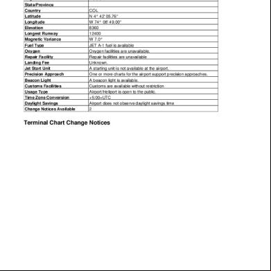
Skbo Jeppesen Chart 2018 5x151o
December 2019 170
Jeppesen Charts Skbo 4a5k34
May 2020 6
Jeppesen Chart 3sv15
November 2019 61
Skbo 35d15
June 2021 0
Jeppesen Chart Clinic 1cp69
December 2019 40
Vhhh Jeppesen Chart 661g2v
November 2019 34More Documents from "Jose Daniel Arango" 4q721c
Skbo Jeppesen Chart 2018 5x151o
December 2019 170
Kjfk.pdf z25h
November 2019 34
Bitacora Digital Segundo Corte 2.pdf 444266
February 2023 0
El Cuadre De Caja 2t4p5k
February 2023 0
Claves Oculares 455b40
December 2019 57